Henderson geodata
Henderson (Nevada) is a populated place; located in United States in America/Los_Angeles (GMT-7) time zone. With population of 285,667 people, there are 74 cities with bigger population in this country. Compared to other cities in United States, 70.3% of cities are located further ↑North; 88.9% of cities are located further →East and 89.2% of cities have lower elevation than Henderson. Note1


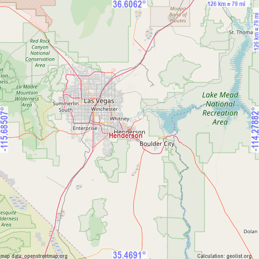
Henderson GPS coordinates[2]
36° 2' 22.92" North, 114° 58' 54.984" West
| Map corner | latitude | longitude |
|---|---|---|
| Upper-left | 36.6062°, | -115.68507° |
| Center: | 36.0397°, | -114.98194° |
| Lower-right: | 35.4691°, | -114.27882° |
| Map W x H: | 126.4×126.4 km | = 78.5×78.5mi |
| max Lat: | 71.29058° ⇑70.3% North |
| Henderson: | 36.0397° |
| min Lat: | ⇓29.7% South 19.06759° |
| min Long | Henderson | max Long |
| -171.73463° | -114.98194° | -66.98998° |
| W 11.1%⇐ | ⇒88.9% E |
Elevation
Elevation of Henderson is 572 m = 1877 ft, and this is 277.2 m = 909 ft above average elevation for this country.
| Max E: |
3189 m = 10463 ft | 10.8% |
| Henderson | 572 m 1877 ft | |
| Avg. | 294.8 m = 967 ft | |
Min E: |
-60 m = -197 ft | 89.2% |
See also: Henderson elevation on elevation.city.
Geographical zone
Henderson is located in North temperate zone (between Tropic of Cancer and the Arctic Circle). Distance of this Northern Tropic circle is 1401.3 km =870.7 mi to South.| Distance of | km | miles | from Henderson |
|---|---|---|---|
| North Pole | 5999.8 | 3728.1 | to North |
| Arctic Circle | 3393.9 | 2108.9 | to North |
| Tropic Cancer | 1401.3 | 870.7 | to South |
| Equator | 4007.2 | 2490 | to South |


Nearby cities:
15 places around Henderson: (largest is in red/bold)
• Boulder City
15.1 km =9.4 mi,  116°
116°
• Enterprise
23.4 km =14.5 mi,  266°
266°
• Las Vegas
20.5 km =12.7 mi,  317°
317°
• Moapa Town
79.4 km =49.3 mi,  25°
25°
• Moapa Valley
75.6 km =47 mi,  37°
37°
• Nellis Air Force Base
23.9 km =14.9 mi,  343°
343°
• North Las Vegas
21.5 km =13.4 mi,  325°
325°
• Paradise
16.1 km =10 mi,  293°
293°
• Sandy Valley
63.6 km =39.5 mi,  247°
247°
• Searchlight
64.1 km =39.8 mi,  174°
174°
• Spring Valley
24.8 km =15.4 mi, 287°
• Summerlin South
32.4 km =20.1 mi, 285°
• Sunrise Manor
20.7 km =12.9 mi, 336°
• Whitney
8.1 km =5 mi, 323°
• Winchester
15.9 km =9.9 mi,  309°
309°
Sources, notices
• [Note1] Compared only with cities in United States existing in our database
• [Src1] Map data: © OpenStreetMap contributors (CC-BY-SA)
• [Src2] Other city data from geonames.org with taken over terms of usage.
• [Src3] Geographical zone / Annual Mean Temperature by Robert A. Rohde @ Wikipedia
