Nellis Air Force Base geodata
Nellis Air Force Base (Nevada) is a populated place; located in United States in America/Los_Angeles (GMT-7) time zone. With population of 3,187 people, there are 9321 cities with bigger population in this country. Compared to other cities in United States, 69.2% of cities are located further ↑North; 88.9% of cities are located further →East and 89.3% of cities have lower elevation than Nellis Air Force Base. Note1
Current local time in Nellis Air Force Base:
11:55 AM, WednesdayDifference from your time zone: hours


Nellis Air Force Base GPS coordinates[2]
36° 14' 45.852" North, 115° 3' 25.956" West
| Map corner | latitude | longitude |
|---|---|---|
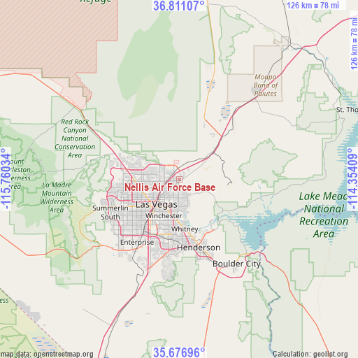
| Upper-left | 36.81107°, | -115.76034° |
| Center: | 36.24607°, | -115.05721° |
| Lower-right: | 35.67696°, | -114.35409° |
| Map W x H: | 126.1×126.1 km | = 78.4×78.4mi |
| max Lat: | 71.29058° ⇑69.2% North |
| Nellis Air Force Base: | 36.24607° |
| min Lat: | ⇓30.8% South 19.06759° |
| min Long | Nellis Air Forc | max Long |
| -171.73463° | -115.05721° | -66.98998° |
| W 11.1%⇐ | ⇒88.9% E |
Elevation
Elevation of Nellis Air Force Base is 577 m = 1893 ft, and this is 282.2 m = 926 ft above average elevation for this country.
| Max E: |
3189 m = 10463 ft | 10.7% |
| Nellis Air Force Base | 577 m 1893 ft | |
| Avg. | 294.8 m = 967 ft | |
Min E: |
-60 m = -197 ft | 89.3% |
See also: United States elevation on elevation.city.
Geographical zone
Nellis Air Force Base is located in North temperate zone (between Tropic of Cancer and the Arctic Circle). Distance of this Northern Tropic circle is 1424.3 km =885 mi to South.| Distance of | km | miles | from Nellis Air Force Base |
|---|---|---|---|
| North Pole | 5976.9 | 3713.9 | to North |
| Arctic Circle | 3371 | 2094.6 | to North |
| Tropic Cancer | 1424.3 | 885 | to South |
| Equator | 4030.2 | 2504.2 | to South |


Nearby cities:
15 places around Nellis Air Force Base: (largest is in red/bold)
• Boulder City
35.9 km =22.3 mi,  145°
145°
• Enterprise
29.6 km =18.4 mi,  214°
214°
• Henderson
23.9 km =14.9 mi,  163°
163°
• Indian Springs
65.6 km =40.8 mi,  303°
303°
• Las Vegas
10.7 km =6.6 mi,  222°
222°
• Moapa Town
63.8 km =39.6 mi,  40°
40°
• Moapa Valley
64.4 km =40 mi,  54°
54°
• North Las Vegas
7.5 km =4.7 mi,  225°
225°
• Paradise
18.4 km =11.4 mi, 205°
• Sandy Valley
70.4 km =43.7 mi, 227°
• Spring Valley
22.8 km =14.2 mi, 227°
• Summerlin South
28.4 km =17.6 mi,  239°
239°
• Sunrise Manor
4.1 km =2.5 mi,  200°
200°
• Whitney
16.5 km =10.3 mi,  173°
173°
• Winchester
14 km =8.7 mi, 203°
Sources, notices
• [Note1] Compared only with cities in United States existing in our database
• [Src1] Map data: © OpenStreetMap contributors (CC-BY-SA)
• [Src2] Other city data from geonames.org with taken over terms of usage.
• [Src3] Geographical zone / Annual Mean Temperature by Robert A. Rohde @ Wikipedia
