Moapa Town geodata
Moapa Town (Nevada) is a populated place; located in United States in America/Los_Angeles (GMT-7) time zone. With population of 1,025 people, there are 16113 cities with bigger population in this country. Compared to other cities in United States, 67.4% of cities are located further ↑North; 88.8% of cities are located further →East and 87.6% of cities have lower elevation than Moapa Town. Note1


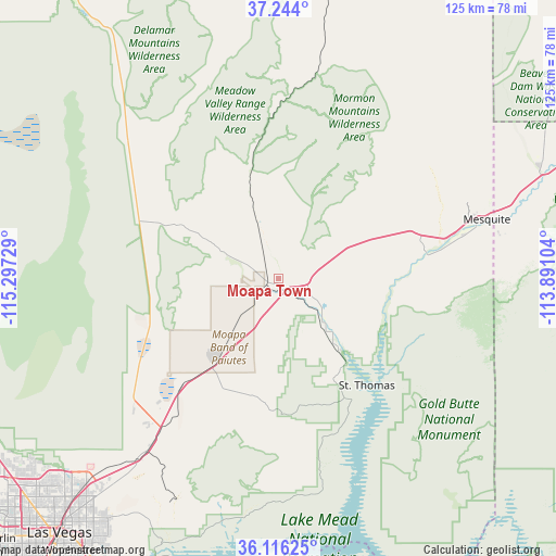
Moapa Town GPS coordinates[2]
36° 40' 55.884" North, 114° 35' 38.976" West
| Map corner | latitude | longitude |
|---|---|---|
| Upper-left | 37.244°, | -115.29729° |
| Center: | 36.68219°, | -114.59416° |
| Lower-right: | 36.11625°, | -113.89104° |
| Map W x H: | 125.4×125.4 km | = 77.9×77.9mi |
| max Lat: | 71.29058° ⇑67.4% North |
| Moapa Town: | 36.68219° |
| min Lat: | ⇓32.6% South 19.06759° |
| min Long | Moapa Town | max Long |
| -171.73463° | -114.59416° | -66.98998° |
| W 11.2%⇐ | ⇒88.8% E |
Elevation
Elevation of Moapa Town is 491 m = 1611 ft, and this is 196.2 m = 644 ft above average elevation for this country.
| Max E: |
3189 m = 10463 ft | 12.4% |
| Moapa Town | 491 m 1611 ft | |
| Avg. | 294.8 m = 967 ft | |
Min E: |
-60 m = -197 ft | 87.6% |
See also: United States elevation on elevation.city.
Geographical zone
Moapa Town is located in North temperate zone (between Tropic of Cancer and the Arctic Circle). Distance of this Northern Tropic circle is 1472.8 km =915.2 mi to South.| Distance of | km | miles | from Moapa Town |
|---|---|---|---|
| North Pole | 5928.4 | 3683.7 | to North |
| Arctic Circle | 3322.5 | 2064.5 | to North |
| Tropic Cancer | 1472.8 | 915.2 | to South |
| Equator | 4078.7 | 2534.4 | to South |


Nearby cities:
15 places around Moapa Town: (largest is in red/bold)
• Beaver Dam
63.7 km =39.6 mi,  67°
67°
• Boulder City
81.1 km =50.4 mi,  195°
195°
• Bunkerville
42.8 km =26.6 mi,  76°
76°
• Henderson
79.4 km =49.3 mi,  205°
205°
• Las Vegas
74.4 km =46.2 mi,  220°
220°
• Mesquite
48.9 km =30.4 mi, 73°
• Moapa Valley
15.8 km =9.8 mi,  135°
135°
• Nellis Air Force Base
63.8 km =39.6 mi, 220°
• North Las Vegas
71.3 km =44.3 mi, 221°
• Paradise
81.7 km =50.8 mi, 217°
• Scenic
53.3 km =33.1 mi, 76°
• Spring Valley
86.4 km =53.7 mi, 222°
• Sunrise Manor
67.7 km =42.1 mi, 219°
• Whitney
76 km =47.2 mi, 211°
• Winchester
77.3 km =48 mi, 217°
Sources, notices
• [Note1] Compared only with cities in United States existing in our database
• [Src1] Map data: © OpenStreetMap contributors (CC-BY-SA)
• [Src2] Other city data from geonames.org with taken over terms of usage.
• [Src3] Geographical zone / Annual Mean Temperature by Robert A. Rohde @ Wikipedia
