Bunkerville geodata
Bunkerville (Nevada) is a populated place; located in United States in America/Los_Angeles (GMT-7) time zone. With population of 1,303 people, there are 14583 cities with bigger population in this country. Compared to other cities in United States, 67% of cities are located further ↑North; 88.5% of cities are located further →East and 87% of cities have lower elevation than Bunkerville. Note1


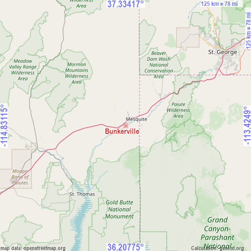
Bunkerville GPS coordinates[2]
36° 46' 22.908" North, 114° 7' 40.872" West
| Map corner | latitude | longitude |
|---|---|---|
| Upper-left | 37.33417°, | -114.83115° |
| Center: | 36.77303°, | -114.12802° |
| Lower-right: | 36.20775°, | -113.4249° |
| Map W x H: | 125.2×125.2 km | = 77.8×77.8mi |
| max Lat: | 71.29058° ⇑67% North |
| Bunkerville: | 36.77303° |
| min Lat: | ⇓33% South 19.06759° |
| min Long | Bunkerville | max Long |
| -171.73463° | -114.12802° | -66.98998° |
| W 11.5%⇐ | ⇒88.5% E |
Elevation
Elevation of Bunkerville is 468 m = 1535 ft, and this is 173.2 m = 568 ft above average elevation for this country.
| Max E: |
3189 m = 10463 ft | 13% |
| Bunkerville | 468 m 1535 ft | |
| Avg. | 294.8 m = 967 ft | |
Min E: |
-60 m = -197 ft | 87% |
See also: United States elevation on elevation.city.
Geographical zone
Bunkerville is located in North temperate zone (between Tropic of Cancer and the Arctic Circle). Distance of this Northern Tropic circle is 1482.9 km =921.4 mi to South.| Distance of | km | miles | from Bunkerville |
|---|---|---|---|
| North Pole | 5918.3 | 3677.5 | to North |
| Arctic Circle | 3312.4 | 2058.2 | to North |
| Tropic Cancer | 1482.9 | 921.4 | to South |
| Equator | 4088.8 | 2540.7 | to South |


Nearby cities:
15 places around Bunkerville: (largest is in red/bold)
• Beaver Dam
22.3 km =13.9 mi,  51°
51°
• Central
84.4 km =52.4 mi,  31°
31°
• Dammeron Valley
71.8 km =44.6 mi, 34°
• Hurricane
86.8 km =53.9 mi,  59°
59°
• Ivins
59.4 km =36.9 mi,  42°
42°
• LaVerkin
89.9 km =55.9 mi, 58°
• Leeds
85.7 km =53.3 mi, 52°
• Meadview
85.9 km =53.4 mi,  176°
176°
• Mesquite
6.5 km =4 mi, 56°
• Moapa Town
42.8 km =26.6 mi,  256°
256°
• Moapa Valley
37.3 km =23.2 mi,  234°
234°
• Saint George
60.8 km =37.8 mi, 52°
• Santa Clara
58.1 km =36.1 mi, 46°
• Scenic
10.5 km =6.5 mi,  77°
77°
• Washington
67.9 km =42.2 mi, 54°
Sources, notices
• [Note1] Compared only with cities in United States existing in our database
• [Src1] Map data: © OpenStreetMap contributors (CC-BY-SA)
• [Src2] Other city data from geonames.org with taken over terms of usage.
• [Src3] Geographical zone / Annual Mean Temperature by Robert A. Rohde @ Wikipedia
