Dolan Springs geodata
Dolan Springs (Arizona) is a populated place; located in United States in America/Phoenix (GMT-7) time zone. With population of 2,033 people, there are 11851 cities with bigger population in this country. Compared to other cities in United States, 72.2% of cities are located further ↑North; 88.6% of cities are located further →East and 93.6% of cities have lower elevation than Dolan Springs. Note1


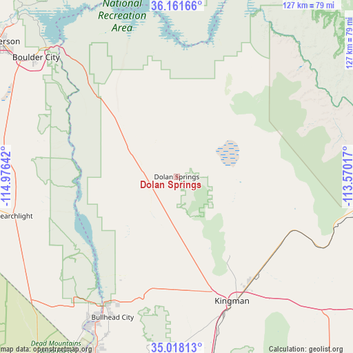
Dolan Springs GPS coordinates[2]
35° 35' 30.984" North, 114° 16' 23.844" West
| Map corner | latitude | longitude |
|---|---|---|
| Upper-left | 36.16166°, | -114.97642° |
| Center: | 35.59194°, | -114.27329° |
| Lower-right: | 35.01813°, | -113.57017° |
| Map W x H: | 127.1×127.1 km | = 79×79mi |
| max Lat: | 71.29058° ⇑72.2% North |
| Dolan Springs: | 35.59194° |
| min Lat: | ⇓27.8% South 19.06759° |
| min Long | Dolan Springs | max Long |
| -171.73463° | -114.27329° | -66.98998° |
| W 11.4%⇐ | ⇒88.6% E |
Elevation
Elevation of Dolan Springs is 1030 m = 3379 ft, and this is 735.2 m = 2412 ft above average elevation for this country.
| Max E: |
3189 m = 10463 ft | 6.4% |
| Dolan Springs | 1030 m 3379 ft | |
| Avg. | 294.8 m = 967 ft | |
Min E: |
-60 m = -197 ft | 93.6% |
See also: United States elevation on elevation.city.
Geographical zone
Dolan Springs is located in North temperate zone (between Tropic of Cancer and the Arctic Circle). Distance of this Northern Tropic circle is 1351.5 km =839.8 mi to South.| Distance of | km | miles | from Dolan Springs |
|---|---|---|---|
| North Pole | 6049.6 | 3759 | to North |
| Arctic Circle | 3443.7 | 2139.8 | to North |
| Tropic Cancer | 1351.5 | 839.8 | to South |
| Equator | 3957.5 | 2459.1 | to South |


Nearby cities:
15 places around Dolan Springs: (largest is in red/bold)
• Arizona Village
86.9 km =54 mi,  198°
198°
• Boulder City
66.3 km =41.2 mi,  310°
310°
• Bullhead City
56.2 km =34.9 mi,  208°
208°
• Golden Valley
41.2 km =25.6 mi,  173°
173°
• Henderson
81 km =50.3 mi, 307°
• Kingman
49 km =30.4 mi,  155°
155°
• Laughlin
54.4 km =33.8 mi, 209°
• Meadview
49.2 km =30.6 mi,  22°
22°
• Mohave Valley
78.7 km =48.9 mi, 201°
• New Kingman-Butler
42.4 km =26.3 mi,  149°
149°
• Peach Springs
77 km =47.8 mi,  95°
95°
• Searchlight
60.2 km =37.4 mi,  256°
256°
• Valle Vista
42.3 km =26.3 mi,  118°
118°
• Walnut Creek
52.9 km =32.9 mi, 165°
• Willow Valley
81.4 km =50.6 mi, 201°
Sources, notices
• [Note1] Compared only with cities in United States existing in our database
• [Src1] Map data: © OpenStreetMap contributors (CC-BY-SA)
• [Src2] Other city data from geonames.org with taken over terms of usage.
• [Src3] Geographical zone / Annual Mean Temperature by Robert A. Rohde @ Wikipedia
