Sundown geodata
Sundown (Texas) is a populated place; located in United States in America/Chicago (GMT-5) time zone. With population of 1,422 people, there are 14002 cities with bigger population in this country. Compared to other cities in United States, 83.3% of cities are located further ↑North; 82.1% of cities are located further →East and 93.9% of cities have lower elevation than Sundown. Note1


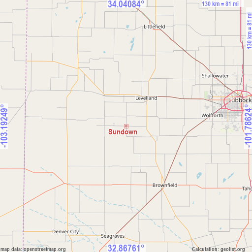
Sundown GPS coordinates[2]
33° 27' 22.356" North, 102° 29' 21.696" West
| Map corner | latitude | longitude |
|---|---|---|
| Upper-left | 34.04084°, | -103.19249° |
| Center: | 33.45621°, | -102.48936° |
| Lower-right: | 32.86761°, | -101.78624° |
| Map W x H: | 130.5×130.5 km | = 81.1×81.1mi |
| max Lat: | 71.29058° ⇑83.3% North |
| Sundown: | 33.45621° |
| min Lat: | ⇓16.7% South 19.06759° |
| min Long | Sundown | max Long |
| -171.73463° | -102.48936° | -66.98998° |
| W 17.9%⇐ | ⇒82.1% E |
Elevation
Elevation of Sundown is 1080 m = 3543 ft, and this is 785.2 m = 2576 ft above average elevation for this country.
| Max E: |
3189 m = 10463 ft | 6.1% |
| Sundown | 1080 m 3543 ft | |
| Avg. | 294.8 m = 967 ft | |
Min E: |
-60 m = -197 ft | 93.9% |
See also: United States elevation on elevation.city.
Geographical zone
Sundown is located in North temperate zone (between Tropic of Cancer and the Arctic Circle). Distance of this Northern Tropic circle is 1114.1 km =692.3 mi to South.| Distance of | km | miles | from Sundown |
|---|---|---|---|
| North Pole | 6287.1 | 3906.6 | to North |
| Arctic Circle | 3681.2 | 2287.4 | to North |
| Tropic Cancer | 1114.1 | 692.3 | to South |
| Equator | 3720 | 2311.5 | to South |


Nearby cities:
15 places around Sundown: (largest is in red/bold)
• Amherst
62 km =38.5 mi,  6°
6°
• Anton
49.7 km =30.9 mi,  37°
37°
• Brownfield
36.5 km =22.7 mi,  146°
146°
• Denver City
63.1 km =39.2 mi,  210°
210°
• Levelland
17.9 km =11.1 mi, 35°
• Littlefield
53.5 km =33.2 mi,  16°
16°
• Lubbock
60.3 km =37.5 mi,  77°
77°
• Meadow
29.4 km =18.3 mi,  116°
116°
• Morton
39 km =24.2 mi,  320°
320°
• New Deal
68.1 km =42.3 mi,  62°
62°
• Plains
43.3 km =26.9 mi,  226°
226°
• Seagraves
57.4 km =35.7 mi,  187°
187°
• Shallowater
52.3 km =32.5 mi, 60°
• Sudan
68.1 km =42.3 mi,  357°
357°
• Wolfforth
44.9 km =27.9 mi, 82°
Sources, notices
• [Note1] Compared only with cities in United States existing in our database
• [Src1] Map data: © OpenStreetMap contributors (CC-BY-SA)
• [Src2] Other city data from geonames.org with taken over terms of usage.
• [Src3] Geographical zone / Annual Mean Temperature by Robert A. Rohde @ Wikipedia
