Garden City geodata
Garden City (Texas) is a seat of a second-order administrative division; located in United States in America/Chicago (GMT-5) time zone. With population of 334 people, there are 20963 cities with bigger population in this country. Compared to other cities in United States, 88.9% of cities are located further ↑North; 81.6% of cities are located further →East and 92.1% of cities have lower elevation than Garden City. Note1


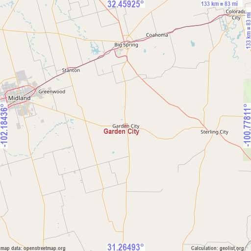
Garden City GPS coordinates[2]
31° 51' 50.472" North, 101° 28' 52.428" West
| Map corner | latitude | longitude |
|---|---|---|
| Upper-left | 32.45925°, | -102.18436° |
| Center: | 31.86402°, | -101.48123° |
| Lower-right: | 31.26493°, | -100.77811° |
| Map W x H: | 132.8×132.8 km | = 82.5×82.5mi |
| max Lat: | 71.29058° ⇑88.9% North |
| Garden City: | 31.86402° |
| min Lat: | ⇓11.1% South 19.06759° |
| min Long | Garden City | max Long |
| -171.73463° | -101.48123° | -66.98998° |
| W 18.4%⇐ | ⇒81.6% E |
Elevation
Elevation of Garden City is 805 m = 2641 ft, and this is 510.2 m = 1674 ft above average elevation for this country.
| Max E: |
3189 m = 10463 ft | 7.9% |
| Garden City | 805 m 2641 ft | |
| Avg. | 294.8 m = 967 ft | |
Min E: |
-60 m = -197 ft | 92.1% |
See also: United States elevation on elevation.city.
Geographical zone
Garden City is located in North temperate zone (between Tropic of Cancer and the Arctic Circle). Distance of this Northern Tropic circle is 937 km =582.2 mi to South.| Distance of | km | miles | from Garden City |
|---|---|---|---|
| North Pole | 6464.1 | 4016.6 | to North |
| Arctic Circle | 3858.2 | 2397.4 | to North |
| Tropic Cancer | 937 | 582.2 | to South |
| Equator | 3542.9 | 2201.5 | to South |


Nearby cities:
15 places around Garden City: (largest is in red/bold)
• Big Lake
74.8 km =46.5 mi,  178°
178°
• Big Spring
43 km =26.7 mi,  0°
0°
• Carlsbad
84.3 km =52.4 mi,  109°
109°
• Coahoma
50.8 km =31.6 mi,  18°
18°
• Colorado City
82.3 km =51.1 mi,  44°
44°
• Gardendale
86.6 km =53.8 mi,  281°
281°
• Grape Creek
93.8 km =58.3 mi, 109°
• Mertzon
91.9 km =57.1 mi,  136°
136°
• Midland
58.2 km =36.2 mi, 284°
• Odessa
83.7 km =52 mi,  268°
268°
• Rankin
83.4 km =51.8 mi,  211°
211°
• Robert Lee
94.1 km =58.5 mi,  88°
88°
• Sand Springs
48.1 km =29.9 mi,  14°
14°
• Stanton
41.3 km =25.7 mi,  315°
315°
• Sterling City
47 km =29.2 mi, 93°
Sources, notices
• [Note1] Compared only with cities in United States existing in our database
• [Src1] Map data: © OpenStreetMap contributors (CC-BY-SA)
• [Src2] Other city data from geonames.org with taken over terms of usage.
• [Src3] Geographical zone / Annual Mean Temperature by Robert A. Rohde @ Wikipedia
