Rankin geodata
Rankin (Texas) is a seat of a second-order administrative division; located in United States in America/Chicago (GMT-5) time zone. With population of 844 people, there are 17412 cities with bigger population in this country. Compared to other cities in United States, 90.3% of cities are located further ↑North; 81.8% of cities are located further →East and 91.6% of cities have lower elevation than Rankin. Note1


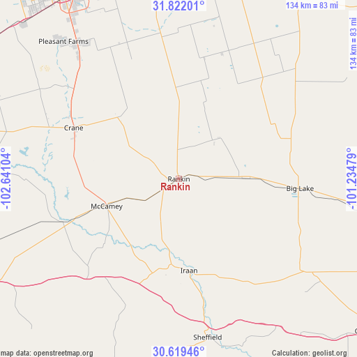
Rankin GPS coordinates[2]
31° 13' 21.54" North, 101° 56' 16.476" West
| Map corner | latitude | longitude |
|---|---|---|
| Upper-left | 31.82201°, | -102.64104° |
| Center: | 31.22265°, | -101.93791° |
| Lower-right: | 30.61946°, | -101.23479° |
| Map W x H: | 133.7×133.7 km | = 83.1×83.1mi |
| max Lat: | 71.29058° ⇑90.3% North |
| Rankin: | 31.22265° |
| min Lat: | ⇓9.7% South 19.06759° |
| min Long | Rankin | max Long |
| -171.73463° | -101.93791° | -66.98998° |
| W 18.2%⇐ | ⇒81.8% E |
Elevation
Elevation of Rankin is 764 m = 2507 ft, and this is 469.2 m = 1539 ft above average elevation for this country.
| Max E: |
3189 m = 10463 ft | 8.4% |
| Rankin | 764 m 2507 ft | |
| Avg. | 294.8 m = 967 ft | |
Min E: |
-60 m = -197 ft | 91.6% |
See also: United States elevation on elevation.city.
Geographical zone
Rankin is located in North temperate zone (between Tropic of Cancer and the Arctic Circle). Distance of this Northern Tropic circle is 865.7 km =537.9 mi to South.| Distance of | km | miles | from Rankin |
|---|---|---|---|
| North Pole | 6535.4 | 4060.9 | to North |
| Arctic Circle | 3929.5 | 2441.7 | to North |
| Tropic Cancer | 865.7 | 537.9 | to South |
| Equator | 3471.6 | 2157.2 | to South |


Nearby cities:
15 places around Rankin: (largest is in red/bold)
• Big Lake
45.5 km =28.3 mi,  94°
94°
• Crane
43.7 km =27.2 mi,  296°
296°
• Fort Stockton
96.8 km =60.1 mi,  247°
247°
• Garden City
83.4 km =51.8 mi,  31°
31°
• Gardendale
98.1 km =61 mi,  334°
334°
• Iraan
34.5 km =21.4 mi,  173°
173°
• McCamey
28.9 km =18 mi, 250°
• Mertzon
106.6 km =66.2 mi, 87°
• Midland
87.2 km =54.2 mi,  351°
351°
• Monahans
99.6 km =61.9 mi,  294°
294°
• Odessa
80.4 km =50 mi, 329°
• Ozona
90.5 km =56.2 mi,  129°
129°
• Stanton
101.8 km =63.3 mi,  7°
7°
• Thorntonville
101.5 km =63.1 mi, 293°
• West Odessa
87 km =54.1 mi,  322°
322°
Sources, notices
• [Note1] Compared only with cities in United States existing in our database
• [Src1] Map data: © OpenStreetMap contributors (CC-BY-SA)
• [Src2] Other city data from geonames.org with taken over terms of usage.
• [Src3] Geographical zone / Annual Mean Temperature by Robert A. Rohde @ Wikipedia
