Midland geodata
Midland (Texas) is a seat of a second-order administrative division; located in United States in America/Chicago (GMT-5) time zone. With population of 132,950 people, there are 227 cities with bigger population in this country. Compared to other cities in United States, 88.6% of cities are located further ↑North; 81.9% of cities are located further →East and 92.5% of cities have lower elevation than Midland. Note1


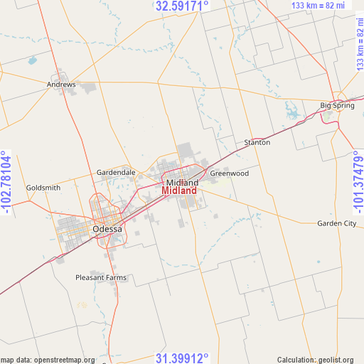
Midland GPS coordinates[2]
31° 59' 50.46" North, 102° 4' 40.476" West
| Map corner | latitude | longitude |
|---|---|---|
| Upper-left | 32.59171°, | -102.78104° |
| Center: | 31.99735°, | -102.07791° |
| Lower-right: | 31.39912°, | -101.37479° |
| Map W x H: | 132.6×132.6 km | = 82.4×82.4mi |
| max Lat: | 71.29058° ⇑88.6% North |
| Midland: | 31.99735° |
| min Lat: | ⇓11.4% South 19.06759° |
| min Long | Midland | max Long |
| -171.73463° | -102.07791° | -66.98998° |
| W 18.1%⇐ | ⇒81.9% E |
Elevation
Elevation of Midland is 862 m = 2828 ft, and this is 567.2 m = 1861 ft above average elevation for this country.
| Max E: |
3189 m = 10463 ft | 7.5% |
| Midland | 862 m 2828 ft | |
| Avg. | 294.8 m = 967 ft | |
Min E: |
-60 m = -197 ft | 92.5% |
See also: Midland elevation on elevation.city.
Geographical zone
Midland is located in North temperate zone (between Tropic of Cancer and the Arctic Circle). Distance of this Northern Tropic circle is 951.9 km =591.5 mi to South.| Distance of | km | miles | from Midland |
|---|---|---|---|
| North Pole | 6449.3 | 4007.4 | to North |
| Arctic Circle | 3843.4 | 2388.2 | to North |
| Tropic Cancer | 951.9 | 591.5 | to South |
| Equator | 3557.8 | 2210.7 | to South |


Nearby cities:
15 places around Midland: (largest is in red/bold)
• Andrews
56.7 km =35.2 mi,  309°
309°
• Big Spring
63 km =39.1 mi,  63°
63°
• Coahoma
79.9 km =49.6 mi,  65°
65°
• Crane
71.5 km =44.4 mi,  201°
201°
• Garden City
58.2 km =36.2 mi,  104°
104°
• Gardendale
28.6 km =17.8 mi,  275°
275°
• Lamesa
83.2 km =51.7 mi,  8°
8°
• McKinney Acres
54.3 km =33.7 mi, 308°
• Monahans
89.1 km =55.4 mi,  239°
239°
• Odessa
32.1 km =19.9 mi, 238°
• Rankin
87.2 km =54.2 mi,  171°
171°
• Sand Springs
75.4 km =46.9 mi, 65°
• Stanton
31 km =19.3 mi, 61°
• Thorntonville
92 km =57.2 mi, 239°
• West Odessa
43.3 km =26.9 mi,  246°
246°
Sources, notices
• [Note1] Compared only with cities in United States existing in our database
• [Src1] Map data: © OpenStreetMap contributors (CC-BY-SA)
• [Src2] Other city data from geonames.org with taken over terms of usage.
• [Src3] Geographical zone / Annual Mean Temperature by Robert A. Rohde @ Wikipedia
