Happy geodata
Happy (Texas) is a populated place; located in United States in America/Chicago (GMT-5) time zone. With population of 656 people, there are 19123 cities with bigger population in this country. Compared to other cities in United States, 76.6% of cities are located further ↑North; 81.8% of cities are located further →East and 94% of cities have lower elevation than Happy. Note1


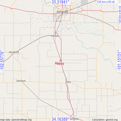
Happy GPS coordinates[2]
34° 44' 37.212" North, 101° 51' 16.668" West
| Map corner | latitude | longitude |
|---|---|---|
| Upper-left | 35.31941°, | -102.55776° |
| Center: | 34.74367°, | -101.85463° |
| Lower-right: | 34.16389°, | -101.15151° |
| Map W x H: | 128.5×128.5 km | = 79.8×79.8mi |
| max Lat: | 71.29058° ⇑76.6% North |
| Happy: | 34.74367° |
| min Lat: | ⇓23.4% South 19.06759° |
| min Long | Happy | max Long |
| -171.73463° | -101.85463° | -66.98998° |
| W 18.2%⇐ | ⇒81.8% E |
Elevation
Elevation of Happy is 1100 m = 3609 ft, and this is 805.2 m = 2642 ft above average elevation for this country.
| Max E: |
3189 m = 10463 ft | 6% |
| Happy | 1100 m 3609 ft | |
| Avg. | 294.8 m = 967 ft | |
Min E: |
-60 m = -197 ft | 94% |
See also: United States elevation on elevation.city.
Geographical zone
Happy is located in North temperate zone (between Tropic of Cancer and the Arctic Circle). Distance of this Northern Tropic circle is 1257.2 km =781.2 mi to South.| Distance of | km | miles | from Happy |
|---|---|---|---|
| North Pole | 6143.9 | 3817.6 | to North |
| Arctic Circle | 3538 | 2198.4 | to North |
| Tropic Cancer | 1257.2 | 781.2 | to South |
| Equator | 3863.1 | 2400.4 | to South |


Nearby cities:
15 places around Happy: (largest is in red/bold)
• Amarillo
53.2 km =33.1 mi,  2°
2°
• Bushland
53.4 km =33.2 mi,  339°
339°
• Canyon
27 km =16.8 mi,  347°
347°
• Claude
60.7 km =37.7 mi,  47°
47°
• Dimmitt
47 km =29.2 mi,  242°
242°
• Hale Center
75.6 km =47 mi,  179°
179°
• Hart
46.5 km =28.9 mi,  210°
210°
• Hereford
50.4 km =31.3 mi,  279°
279°
• Kress
43.1 km =26.8 mi,  166°
166°
• Lake Tanglewood
36.5 km =22.7 mi,  9°
9°
• Olton
67.4 km =41.9 mi,  202°
202°
• Plainview
63.6 km =39.5 mi, 167°
• Seth Ward
61 km =37.9 mi, 165°
• Silverton
58.6 km =36.4 mi,  120°
120°
• Tulia
24.7 km =15.3 mi,  159°
159°
Sources, notices
• [Note1] Compared only with cities in United States existing in our database
• [Src1] Map data: © OpenStreetMap contributors (CC-BY-SA)
• [Src2] Other city data from geonames.org with taken over terms of usage.
• [Src3] Geographical zone / Annual Mean Temperature by Robert A. Rohde @ Wikipedia
