Slaton geodata
Slaton (Texas) is a populated place; located in United States in America/Chicago (GMT-5) time zone. With population of 6,072 people, there are 6355 cities with bigger population in this country. Compared to other cities in United States, 83.4% of cities are located further ↑North; 81.6% of cities are located further →East and 93% of cities have lower elevation than Slaton. Note1


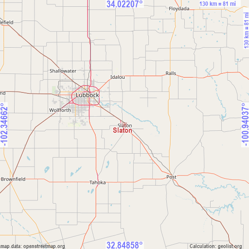
Slaton GPS coordinates[2]
33° 26' 14.316" North, 101° 38' 36.564" West
| Map corner | latitude | longitude |
|---|---|---|
| Upper-left | 34.02207°, | -102.34662° |
| Center: | 33.43731°, | -101.64349° |
| Lower-right: | 32.84858°, | -100.94037° |
| Map W x H: | 130.5×130.5 km | = 81.1×81.1mi |
| max Lat: | 71.29058° ⇑83.4% North |
| Slaton: | 33.43731° |
| min Lat: | ⇓16.6% South 19.06759° |
| min Long | Slaton | max Long |
| -171.73463° | -101.64349° | -66.98998° |
| W 18.4%⇐ | ⇒81.6% E |
Elevation
Elevation of Slaton is 942 m = 3091 ft, and this is 647.2 m = 2123 ft above average elevation for this country.
| Max E: |
3189 m = 10463 ft | 7% |
| Slaton | 942 m 3091 ft | |
| Avg. | 294.8 m = 967 ft | |
Min E: |
-60 m = -197 ft | 93% |
See also: United States elevation on elevation.city.
Geographical zone
Slaton is located in North temperate zone (between Tropic of Cancer and the Arctic Circle). Distance of this Northern Tropic circle is 1112 km =691 mi to South.| Distance of | km | miles | from Slaton |
|---|---|---|---|
| North Pole | 6289.2 | 3907.9 | to North |
| Arctic Circle | 3683.3 | 2288.7 | to North |
| Tropic Cancer | 1112 | 691 | to South |
| Equator | 3717.9 | 2310.2 | to South |


Nearby cities:
15 places around Slaton: (largest is in red/bold)
• Abernathy
47.6 km =29.6 mi,  337°
337°
• Crosbyton
45 km =28 mi,  56°
56°
• Idalou
25.7 km =16 mi,  351°
351°
• Lorenzo
27.8 km =17.3 mi,  21°
21°
• Lubbock
25.1 km =15.6 mi,  308°
308°
• Meadow
53.5 km =33.2 mi,  257°
257°
• New Deal
37.8 km =23.5 mi,  331°
331°
• O'Donnell
55.5 km =34.5 mi,  198°
198°
• Petersburg
48.2 km =30 mi,  5°
5°
• Post
36.8 km =22.9 mi,  138°
138°
• Ralls
35.4 km =22 mi,  41°
41°
• Ransom Canyon
11.2 km =7 mi, 342°
• Shallowater
43.2 km =26.8 mi, 310°
• Tahoka
33.2 km =20.6 mi, 204°
• Wolfforth
34.8 km =21.6 mi,  282°
282°
Sources, notices
• [Note1] Compared only with cities in United States existing in our database
• [Src1] Map data: © OpenStreetMap contributors (CC-BY-SA)
• [Src2] Other city data from geonames.org with taken over terms of usage.
• [Src3] Geographical zone / Annual Mean Temperature by Robert A. Rohde @ Wikipedia
