Tahoka geodata
Tahoka (Texas) is a seat of a second-order administrative division; located in United States in America/Chicago (GMT-5) time zone. With population of 2,570 people, there are 10455 cities with bigger population in this country. Compared to other cities in United States, 84.5% of cities are located further ↑North; 81.7% of cities are located further →East and 93% of cities have lower elevation than Tahoka. Note1


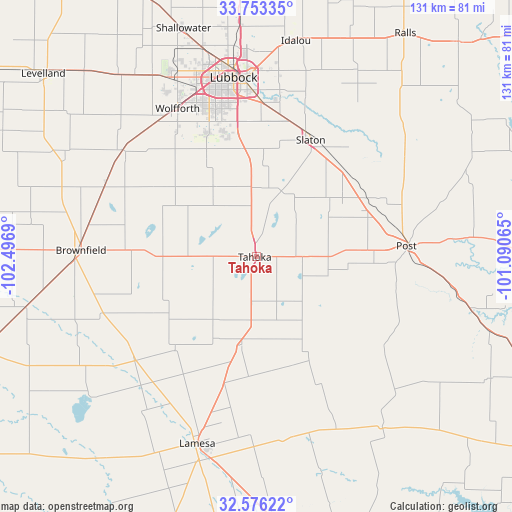
Tahoka GPS coordinates[2]
33° 10' 0.336" North, 101° 47' 37.572" West
| Map corner | latitude | longitude |
|---|---|---|
| Upper-left | 33.75335°, | -102.4969° |
| Center: | 33.16676°, | -101.79377° |
| Lower-right: | 32.57622°, | -101.09065° |
| Map W x H: | 130.9×130.9 km | = 81.3×81.3mi |
| max Lat: | 71.29058° ⇑84.5% North |
| Tahoka: | 33.16676° |
| min Lat: | ⇓15.5% South 19.06759° |
| min Long | Tahoka | max Long |
| -171.73463° | -101.79377° | -66.98998° |
| W 18.3%⇐ | ⇒81.7% E |
Elevation
Elevation of Tahoka is 944 m = 3097 ft, and this is 649.2 m = 2130 ft above average elevation for this country.
| Max E: |
3189 m = 10463 ft | 7% |
| Tahoka | 944 m 3097 ft | |
| Avg. | 294.8 m = 967 ft | |
Min E: |
-60 m = -197 ft | 93% |
See also: United States elevation on elevation.city.
Geographical zone
Tahoka is located in North temperate zone (between Tropic of Cancer and the Arctic Circle). Distance of this Northern Tropic circle is 1081.9 km =672.3 mi to South.| Distance of | km | miles | from Tahoka |
|---|---|---|---|
| North Pole | 6319.3 | 3926.6 | to North |
| Arctic Circle | 3713.4 | 2307.4 | to North |
| Tropic Cancer | 1081.9 | 672.3 | to South |
| Equator | 3687.8 | 2291.5 | to South |


Nearby cities:
15 places around Tahoka: (largest is in red/bold)
• Brownfield
44.8 km =27.8 mi,  272°
272°
• Gail
54.8 km =34.1 mi,  143°
143°
• Idalou
56.5 km =35.1 mi,  10°
10°
• Lamesa
49.9 km =31 mi,  197°
197°
• Lorenzo
61 km =37.9 mi,  23°
23°
• Lubbock
46.1 km =28.6 mi,  352°
352°
• Meadow
42.8 km =26.6 mi,  296°
296°
• New Deal
63.6 km =39.5 mi,  356°
356°
• O'Donnell
22.9 km =14.2 mi,  189°
189°
• Post
38.7 km =24 mi,  85°
85°
• Ralls
67.9 km =42.2 mi,  33°
33°
• Ransom Canyon
42.1 km =26.2 mi, 14°
• Shallowater
61.1 km =38 mi,  341°
341°
• Slaton
33.2 km =20.6 mi, 24°
• Wolfforth
42.7 km =26.5 mi,  332°
332°
Sources, notices
• [Note1] Compared only with cities in United States existing in our database
• [Src1] Map data: © OpenStreetMap contributors (CC-BY-SA)
• [Src2] Other city data from geonames.org with taken over terms of usage.
• [Src3] Geographical zone / Annual Mean Temperature by Robert A. Rohde @ Wikipedia
