Meadow geodata
Meadow (Texas) is a populated place; located in United States in America/Chicago (GMT-5) time zone. With population of 593 people, there are 19785 cities with bigger population in this country. Compared to other cities in United States, 83.8% of cities are located further ↑North; 81.9% of cities are located further →East and 93.5% of cities have lower elevation than Meadow. Note1


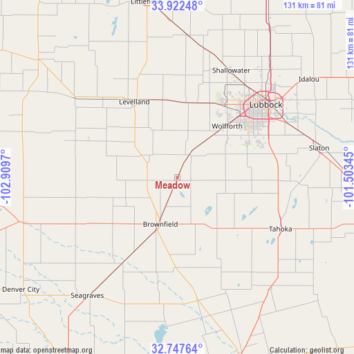
Meadow GPS coordinates[2]
33° 20' 13.344" North, 102° 12' 23.652" West
| Map corner | latitude | longitude |
|---|---|---|
| Upper-left | 33.92248°, | -102.9097° |
| Center: | 33.33704°, | -102.20657° |
| Lower-right: | 32.74764°, | -101.50345° |
| Map W x H: | 130.6×130.6 km | = 81.2×81.2mi |
| max Lat: | 71.29058° ⇑83.8% North |
| Meadow: | 33.33704° |
| min Lat: | ⇓16.2% South 19.06759° |
| min Long | Meadow | max Long |
| -171.73463° | -102.20657° | -66.98998° |
| W 18.1%⇐ | ⇒81.9% E |
Elevation
Elevation of Meadow is 1015 m = 3330 ft, and this is 720.2 m = 2363 ft above average elevation for this country.
| Max E: |
3189 m = 10463 ft | 6.5% |
| Meadow | 1015 m 3330 ft | |
| Avg. | 294.8 m = 967 ft | |
Min E: |
-60 m = -197 ft | 93.5% |
See also: United States elevation on elevation.city.
Geographical zone
Meadow is located in North temperate zone (between Tropic of Cancer and the Arctic Circle). Distance of this Northern Tropic circle is 1100.8 km =684 mi to South.| Distance of | km | miles | from Meadow |
|---|---|---|---|
| North Pole | 6300.3 | 3914.8 | to North |
| Arctic Circle | 3694.4 | 2295.6 | to North |
| Tropic Cancer | 1100.8 | 684 | to South |
| Equator | 3706.7 | 2303.2 | to South |


Nearby cities:
15 places around Meadow: (largest is in red/bold)
• Anton
52.9 km =32.9 mi,  4°
4°
• Brownfield
18.4 km =11.4 mi,  199°
199°
• Idalou
60.8 km =37.8 mi,  52°
52°
• Levelland
32 km =19.9 mi,  330°
330°
• Lubbock
42.2 km =26.2 mi, 50°
• New Deal
56.2 km =34.9 mi,  37°
37°
• O'Donnell
54.2 km =33.7 mi,  140°
140°
• Plains
60.1 km =37.3 mi,  254°
254°
• Ransom Canyon
53.5 km =33.2 mi,  65°
65°
• Seagraves
55 km =34.2 mi,  217°
217°
• Shallowater
43.6 km =27.1 mi,  26°
26°
• Slaton
53.5 km =33.2 mi,  77°
77°
• Sundown
29.4 km =18.3 mi,  296°
296°
• Tahoka
42.8 km =26.6 mi,  116°
116°
• Wolfforth
26.2 km =16.3 mi, 44°
Sources, notices
• [Note1] Compared only with cities in United States existing in our database
• [Src1] Map data: © OpenStreetMap contributors (CC-BY-SA)
• [Src2] Other city data from geonames.org with taken over terms of usage.
• [Src3] Geographical zone / Annual Mean Temperature by Robert A. Rohde @ Wikipedia
