Lake Tanglewood geodata
Lake Tanglewood (Texas) is a populated place; located in United States in America/Chicago (GMT-5) time zone. With population of 863 people, there are 17256 cities with bigger population in this country. Compared to other cities in United States, 75% of cities are located further ↑North; 81.7% of cities are located further →East and 93.8% of cities have lower elevation than Lake Tanglewood. Note1


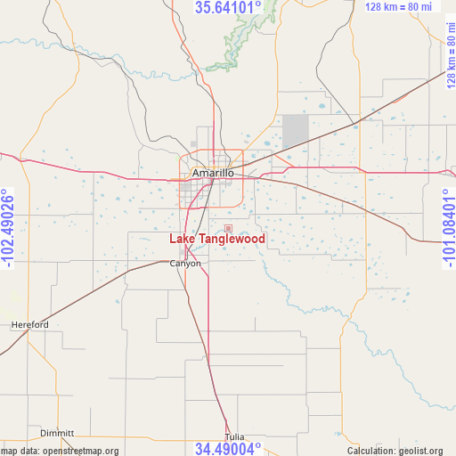
Lake Tanglewood GPS coordinates[2]
35° 4' 3.18" North, 101° 47' 13.668" West
| Map corner | latitude | longitude |
|---|---|---|
| Upper-left | 35.64101°, | -102.49026° |
| Center: | 35.06755°, | -101.78713° |
| Lower-right: | 34.49004°, | -101.08401° |
| Map W x H: | 128×128 km | = 79.5×79.5mi |
| max Lat: | 71.29058° ⇑75% North |
| Lake Tanglewood: | 35.06755° |
| min Lat: | ⇓25% South 19.06759° |
| min Long | Lake Tanglewood | max Long |
| -171.73463° | -101.78713° | -66.98998° |
| W 18.3%⇐ | ⇒81.7% E |
Elevation
Elevation of Lake Tanglewood is 1061 m = 3481 ft, and this is 766.2 m = 2514 ft above average elevation for this country.
| Max E: |
3189 m = 10463 ft | 6.2% |
| Lake Tanglewood | 1061 m 3481 ft | |
| Avg. | 294.8 m = 967 ft | |
Min E: |
-60 m = -197 ft | 93.8% |
See also: United States elevation on elevation.city.
Geographical zone
Lake Tanglewood is located in North temperate zone (between Tropic of Cancer and the Arctic Circle). Distance of this Northern Tropic circle is 1293.2 km =803.6 mi to South.| Distance of | km | miles | from Lake Tanglewood |
|---|---|---|---|
| North Pole | 6107.9 | 3795.3 | to North |
| Arctic Circle | 3502 | 2176 | to North |
| Tropic Cancer | 1293.2 | 803.6 | to South |
| Equator | 3899.1 | 2422.8 | to South |


Nearby cities:
15 places around Lake Tanglewood: (largest is in red/bold)
• Amarillo
17.6 km =10.9 mi,  346°
346°
• Borger
75.5 km =46.9 mi,  27°
27°
• Bushland
28.8 km =17.9 mi,  298°
298°
• Canyon
15.4 km =9.6 mi,  231°
231°
• Claude
38.9 km =24.2 mi,  82°
82°
• Dimmitt
74.8 km =46.5 mi,  219°
219°
• Fritch
65.8 km =40.9 mi,  14°
14°
• Groom
63.7 km =39.6 mi, 76°
• Happy
36.5 km =22.7 mi,  189°
189°
• Hereford
62.5 km =38.8 mi,  243°
243°
• Kress
78 km =48.5 mi,  177°
177°
• Panhandle
48.2 km =30 mi,  50°
50°
• Tulia
59.2 km =36.8 mi, 177°
• Vega
61.5 km =38.2 mi,  288°
288°
• White Deer
69.2 km =43 mi, 53°
Sources, notices
• [Note1] Compared only with cities in United States existing in our database
• [Src1] Map data: © OpenStreetMap contributors (CC-BY-SA)
• [Src2] Other city data from geonames.org with taken over terms of usage.
• [Src3] Geographical zone / Annual Mean Temperature by Robert A. Rohde @ Wikipedia
