Bushland geodata
Bushland (Texas) is a populated place; located in United States in America/Chicago (GMT-5) time zone. With population of 1,500 people, there are 13654 cities with bigger population in this country. Compared to other cities in United States, 74.3% of cities are located further ↑North; 81.9% of cities are located further →East and 94.4% of cities have lower elevation than Bushland. Note1


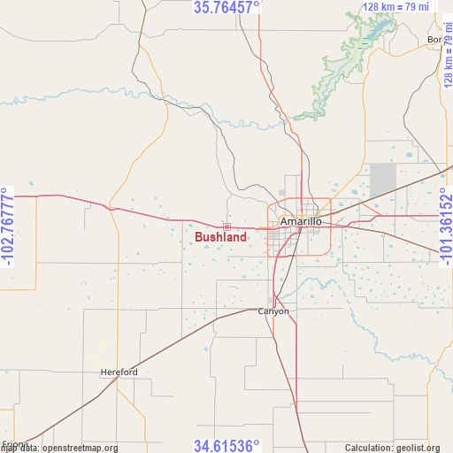
Bushland GPS coordinates[2]
35° 11' 31.2" North, 102° 3' 52.704" West
| Map corner | latitude | longitude |
|---|---|---|
| Upper-left | 35.76457°, | -102.76777° |
| Center: | 35.192°, | -102.06464° |
| Lower-right: | 34.61536°, | -101.36152° |
| Map W x H: | 127.8×127.8 km | = 79.4×79.4mi |
| max Lat: | 71.29058° ⇑74.3% North |
| Bushland: | 35.192° |
| min Lat: | ⇓25.7% South 19.06759° |
| min Long | Bushland | max Long |
| -171.73463° | -102.06464° | -66.98998° |
| W 18.1%⇐ | ⇒81.9% E |
Elevation
Elevation of Bushland is 1177 m = 3862 ft, and this is 882.2 m = 2894 ft above average elevation for this country.
| Max E: |
3189 m = 10463 ft | 5.6% |
| Bushland | 1177 m 3862 ft | |
| Avg. | 294.8 m = 967 ft | |
Min E: |
-60 m = -197 ft | 94.4% |
See also: United States elevation on elevation.city.
Geographical zone
Bushland is located in North temperate zone (between Tropic of Cancer and the Arctic Circle). Distance of this Northern Tropic circle is 1307.1 km =812.2 mi to South.| Distance of | km | miles | from Bushland |
|---|---|---|---|
| North Pole | 6094.1 | 3786.7 | to North |
| Arctic Circle | 3488.2 | 2167.5 | to North |
| Tropic Cancer | 1307.1 | 812.2 | to South |
| Equator | 3913 | 2431.4 | to South |


Nearby cities:
15 places around Bushland: (largest is in red/bold)
• Amarillo
21.5 km =13.4 mi,  81°
81°
• Borger
80.3 km =49.9 mi,  48°
48°
• Canyon
27 km =16.8 mi,  150°
150°
• Channing
59.7 km =37.1 mi,  336°
336°
• Claude
64.4 km =40 mi,  97°
97°
• Dimmitt
74.8 km =46.5 mi,  197°
197°
• Dumas
75.4 km =46.9 mi,  6°
6°
• Fritch
65 km =40.4 mi,  40°
40°
• Happy
53.4 km =33.2 mi,  159°
159°
• Hartley
82.8 km =51.4 mi, 338°
• Hereford
51.8 km =32.2 mi,  216°
216°
• Lake Tanglewood
28.8 km =17.9 mi,  118°
118°
• Panhandle
64.4 km =40 mi,  74°
74°
• Tulia
78.1 km =48.5 mi, 159°
• Vega
33.5 km =20.8 mi,  279°
279°
Sources, notices
• [Note1] Compared only with cities in United States existing in our database
• [Src1] Map data: © OpenStreetMap contributors (CC-BY-SA)
• [Src2] Other city data from geonames.org with taken over terms of usage.
• [Src3] Geographical zone / Annual Mean Temperature by Robert A. Rohde @ Wikipedia
