Anson geodata
Anson (Texas) is a seat of a second-order administrative division; located in United States in America/Chicago (GMT-5) time zone. With population of 2,334 people, there are 11012 cities with bigger population in this country. Compared to other cities in United States, 86.2% of cities are located further ↑North; 80.7% of cities are located further →East and 88.5% of cities have lower elevation than Anson. Note1


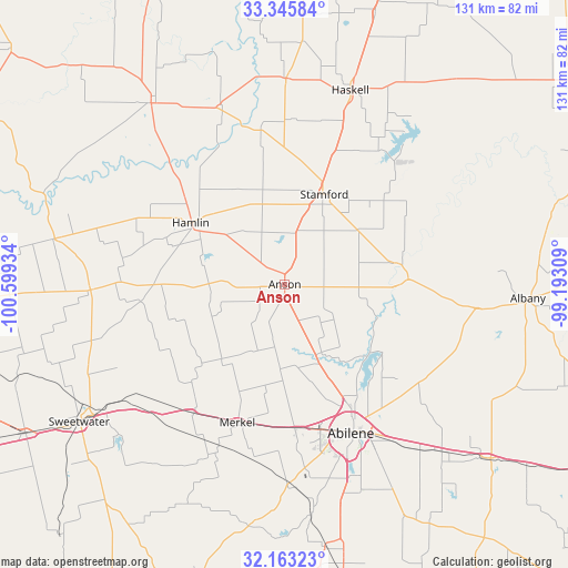
Anson GPS coordinates[2]
32° 45' 23.4" North, 99° 53' 46.356" West
| Map corner | latitude | longitude |
|---|---|---|
| Upper-left | 33.34584°, | -100.59934° |
| Center: | 32.7565°, | -99.89621° |
| Lower-right: | 32.16323°, | -99.19309° |
| Map W x H: | 131.5×131.5 km | = 81.7×81.7mi |
| max Lat: | 71.29058° ⇑86.2% North |
| Anson: | 32.7565° |
| min Lat: | ⇓13.8% South 19.06759° |
| min Long | Anson | max Long |
| -171.73463° | -99.89621° | -66.98998° |
| W 19.3%⇐ | ⇒80.7% E |
Elevation
Elevation of Anson is 532 m = 1745 ft, and this is 237.2 m = 778 ft above average elevation for this country.
| Max E: |
3189 m = 10463 ft | 11.5% |
| Anson | 532 m 1745 ft | |
| Avg. | 294.8 m = 967 ft | |
Min E: |
-60 m = -197 ft | 88.5% |
See also: United States elevation on elevation.city.
Geographical zone
Anson is located in North temperate zone (between Tropic of Cancer and the Arctic Circle). Distance of this Northern Tropic circle is 1036.3 km =643.9 mi to South.| Distance of | km | miles | from Anson |
|---|---|---|---|
| North Pole | 6364.9 | 3955 | to North |
| Arctic Circle | 3759 | 2335.7 | to North |
| Tropic Cancer | 1036.3 | 643.9 | to South |
| Equator | 3642.2 | 2263.2 | to South |


Nearby cities:
15 places around Anson: (largest is in red/bold)
• Abilene
37.5 km =23.3 mi,  155°
155°
• Albany
56.1 km =34.9 mi,  93°
93°
• Aspermont
52.1 km =32.4 mi,  323°
323°
• Clyde
54.2 km =33.7 mi,  135°
135°
• Hamlin
25.8 km =16 mi,  303°
303°
• Haskell
47.1 km =29.3 mi,  18°
18°
• Hawley
17.8 km =11.1 mi,  154°
154°
• Merkel
33.6 km =20.9 mi,  198°
198°
• Potosi
52.5 km =32.6 mi, 154°
• Roby
45 km =28 mi,  268°
268°
• Rotan
54.3 km =33.7 mi,  281°
281°
• Rule
47.6 km =29.6 mi,  0°
0°
• Stamford
22.7 km =14.1 mi, 22°
• Sweetwater
57.3 km =35.6 mi,  236°
236°
• Tye
33.3 km =20.7 mi,  176°
176°
Sources, notices
• [Note1] Compared only with cities in United States existing in our database
• [Src1] Map data: © OpenStreetMap contributors (CC-BY-SA)
• [Src2] Other city data from geonames.org with taken over terms of usage.
• [Src3] Geographical zone / Annual Mean Temperature by Robert A. Rohde @ Wikipedia
