Anthem geodata
Anthem (Arizona) is a populated place; located in United States in America/Phoenix (GMT-7) time zone. With population of 21,700 people, there are 2334 cities with bigger population in this country. Compared to other cities in United States, 81.2% of cities are located further ↑North; 87.8% of cities are located further →East and 89.1% of cities have lower elevation than Anthem. Note1


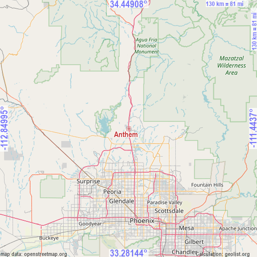
Anthem GPS coordinates[2]
33° 52' 2.136" North, 112° 8' 48.552" West
| Map corner | latitude | longitude |
|---|---|---|
| Upper-left | 34.44908°, | -112.84995° |
| Center: | 33.86726°, | -112.14682° |
| Lower-right: | 33.28144°, | -111.4437° |
| Map W x H: | 129.8×129.8 km | = 80.7×80.7mi |
| max Lat: | 71.29058° ⇑81.2% North |
| Anthem: | 33.86726° |
| min Lat: | ⇓18.8% South 19.06759° |
| min Long | Anthem | max Long |
| -171.73463° | -112.14682° | -66.98998° |
| W 12.2%⇐ | ⇒87.8% E |
Elevation
Elevation of Anthem is 566 m = 1857 ft, and this is 271.2 m = 890 ft above average elevation for this country.
| Max E: |
3189 m = 10463 ft | 10.9% |
| Anthem | 566 m 1857 ft | |
| Avg. | 294.8 m = 967 ft | |
Min E: |
-60 m = -197 ft | 89.1% |
See also: United States elevation on elevation.city.
Geographical zone
Anthem is located in North temperate zone (between Tropic of Cancer and the Arctic Circle). Distance of this Northern Tropic circle is 1159.8 km =720.7 mi to South.| Distance of | km | miles | from Anthem |
|---|---|---|---|
| North Pole | 6241.4 | 3878.2 | to North |
| Arctic Circle | 3635.5 | 2259 | to North |
| Tropic Cancer | 1159.8 | 720.7 | to South |
| Equator | 3765.7 | 2339.9 | to South |


Nearby cities:
15 places around Anthem: (largest is in red/bold)
• Alhambra
41 km =25.5 mi,  178°
178°
• Black Canyon City
22.6 km =14 mi,  359°
359°
• Carefree
21.7 km =13.5 mi,  103°
103°
• Cave Creek
18.5 km =11.5 mi, 101°
• Deer Valley
20.4 km =12.7 mi, 176°
• El Mirage
32.7 km =20.3 mi,  210°
210°
• Glendale
36.7 km =22.8 mi,  185°
185°
• Maryvale
40.7 km =25.3 mi, 184°
• New River
5.5 km =3.4 mi,  10°
10°
• Peoria
33 km =20.5 mi, 194°
• Sun City
32.1 km =19.9 mi,  201°
201°
• Sun City West
29.1 km =18.1 mi,  218°
218°
• Surprise
31.5 km =19.6 mi, 213°
• Wittmann
36.7 km =22.8 mi,  254°
254°
• Youngtown
33.6 km =20.9 mi, 205°
Sources, notices
• [Note1] Compared only with cities in United States existing in our database
• [Src1] Map data: © OpenStreetMap contributors (CC-BY-SA)
• [Src2] Other city data from geonames.org with taken over terms of usage.
• [Src3] Geographical zone / Annual Mean Temperature by Robert A. Rohde @ Wikipedia
