Stanfield geodata
Stanfield (Oregon) is a populated place; located in United States in America/Los_Angeles (GMT-7) time zone. With population of 2,082 people, there are 11687 cities with bigger population in this country. Compared to other cities in United States, 94.7% of cities are located further ↓South; 92.1% of cities are located further →East and 54.8% of cities have higher elevation than Stanfield. Note1


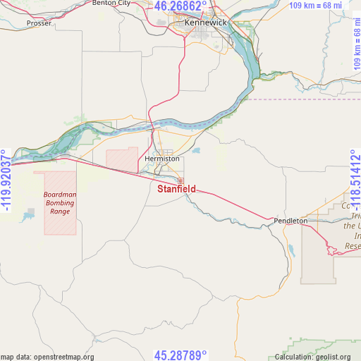
Stanfield GPS coordinates[2]
45° 46' 49.476" North, 119° 13' 2.064" West
| Map corner | latitude | longitude |
|---|---|---|
| Upper-left | 46.26862°, | -119.92037° |
| Center: | 45.78041°, | -119.21724° |
| Lower-right: | 45.28789°, | -118.51412° |
| Map W x H: | 109×109 km | = 67.7×67.7mi |
| max Lat: | 71.29058° ⇑5.3% North |
| Stanfield: | 45.78041° |
| min Lat: | ⇓94.7% South 19.06759° |
| min Long | Stanfield | max Long |
| -171.73463° | -119.21724° | -66.98998° |
| W 7.9%⇐ | ⇒92.1% E |
Elevation
Elevation of Stanfield is 181 m = 594 ft, and this is 113.8 m = 373 ft below average elevation for this country.
| Max E: |
3189 m = 10463 ft | 54.8% |
| Avg. | 294.8 m = 967 ft | |
| Stanfield | 181 m = 594 ft | |
Min E: |
-60 m = -197 ft | 45.2% |
See also: United States elevation on elevation.city.
Geographical zone
Stanfield is located in North temperate zone (between Tropic of Cancer and the Arctic Circle). Distance of this North polar circle is 2310.9 km =1435.9 mi to North.| Distance of | km | miles | from Stanfield |
|---|---|---|---|
| North Pole | 4916.8 | 3055.2 | to North |
| Arctic Circle | 2310.9 | 1435.9 | to North |
| Tropic Cancer | 2484.4 | 1543.7 | to South |
| Equator | 5090.3 | 3163 | to South |


Nearby cities:
15 places around Stanfield: (largest is in red/bold)
• Boardman
38 km =23.6 mi,  280°
280°
• Burbank
49.2 km =30.6 mi,  18°
18°
• Echo
4.6 km =2.9 mi,  158°
158°
• Finley
43.9 km =27.3 mi, 18°
• Heppner
54.4 km =33.8 mi,  209°
209°
• Hermiston
8.7 km =5.4 mi,  320°
320°
• Highland
39.8 km =24.7 mi,  11°
11°
• Irrigon
24.8 km =15.4 mi,  301°
301°
• Kennewick
48.3 km =30 mi, 7°
• Mission
43.2 km =26.8 mi,  106°
106°
• Pasco
51.8 km =32.2 mi, 10°
• Pendleton
35.4 km =22 mi, 109°
• Pilot Rock
44.7 km =27.8 mi,  137°
137°
• Umatilla
18.1 km =11.2 mi,  327°
327°
• West Pasco
51.8 km =32.2 mi,  2°
2°
Sources, notices
• [Note1] Compared only with cities in United States existing in our database
• [Src1] Map data: © OpenStreetMap contributors (CC-BY-SA)
• [Src2] Other city data from geonames.org with taken over terms of usage.
• [Src3] Geographical zone / Annual Mean Temperature by Robert A. Rohde @ Wikipedia
