Irrigon geodata
Irrigon (Oregon) is a populated place; located in United States in America/Los_Angeles (GMT-7) time zone. With population of 1,800 people, there are 12537 cities with bigger population in this country. Compared to other cities in United States, 94.9% of cities are located further ↓South; 92.4% of cities are located further →East and 71.5% of cities have higher elevation than Irrigon. Note1


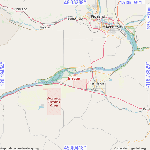
Irrigon GPS coordinates[2]
45° 53' 44.484" North, 119° 29' 29.076" West
| Map corner | latitude | longitude |
|---|---|---|
| Upper-left | 46.38289°, | -120.19454° |
| Center: | 45.89569°, | -119.49141° |
| Lower-right: | 45.40418°, | -118.78829° |
| Map W x H: | 108.8×108.8 km | = 67.6×67.6mi |
| max Lat: | 71.29058° ⇑5.1% North |
| Irrigon: | 45.89569° |
| min Lat: | ⇓94.9% South 19.06759° |
| min Long | Irrigon | max Long |
| -171.73463° | -119.49141° | -66.98998° |
| W 7.6%⇐ | ⇒92.4% E |
Elevation
Elevation of Irrigon is 92 m = 302 ft, and this is 202.8 m = 665 ft below average elevation for this country.
| Max E: |
3189 m = 10463 ft | 71.5% |
| Avg. | 294.8 m = 967 ft | |
| Irrigon | 92 m = 302 ft | |
Min E: |
-60 m = -197 ft | 28.5% |
See also: United States elevation on elevation.city.
Geographical zone
Irrigon is located in North temperate zone (between Tropic of Cancer and the Arctic Circle). Distance of this North polar circle is 2298.1 km =1428 mi to North.| Distance of | km | miles | from Irrigon |
|---|---|---|---|
| North Pole | 4903.9 | 3047.1 | to North |
| Arctic Circle | 2298.1 | 1428 | to North |
| Tropic Cancer | 2497.2 | 1551.7 | to South |
| Equator | 5103.1 | 3170.9 | to South |


Nearby cities:
15 places around Irrigon: (largest is in red/bold)
• Benton City
40.9 km =25.4 mi,  0°
0°
• Boardman
17.3 km =10.7 mi,  249°
249°
• Burbank
50.1 km =31.1 mi,  47°
47°
• Echo
28.6 km =17.8 mi,  126°
126°
• Finley
45.5 km =28.3 mi, 50°
• Hermiston
16.8 km =10.4 mi,  111°
111°
• Highland
39.2 km =24.4 mi, 48°
• Kennewick
44.5 km =27.7 mi,  37°
37°
• Pasco
48.7 km =30.3 mi, 38°
• Prosser
40.7 km =25.3 mi,  328°
328°
• Richland
46.2 km =28.7 mi,  20°
20°
• Stanfield
24.8 km =15.4 mi,  121°
121°
• Umatilla
11.8 km =7.3 mi,  78°
78°
• West Pasco
45.6 km =28.3 mi,  31°
31°
• West Richland
46.5 km =28.9 mi,  12°
12°
Sources, notices
• [Note1] Compared only with cities in United States existing in our database
• [Src1] Map data: © OpenStreetMap contributors (CC-BY-SA)
• [Src2] Other city data from geonames.org with taken over terms of usage.
• [Src3] Geographical zone / Annual Mean Temperature by Robert A. Rohde @ Wikipedia
