Boardman geodata
Boardman (Oregon) is a populated place; located in United States in America/Los_Angeles (GMT-7) time zone. With population of 3,354 people, there are 9058 cities with bigger population in this country. Compared to other cities in United States, 94.8% of cities are located further ↓South; 92.6% of cities are located further →East and 71.1% of cities have higher elevation than Boardman. Note1


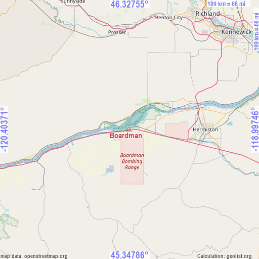
Boardman GPS coordinates[2]
45° 50' 23.496" North, 119° 42' 2.088" West
| Map corner | latitude | longitude |
|---|---|---|
| Upper-left | 46.32755°, | -120.40371° |
| Center: | 45.83986°, | -119.70058° |
| Lower-right: | 45.34786°, | -118.99746° |
| Map W x H: | 108.9×108.9 km | = 67.7×67.7mi |
| max Lat: | 71.29058° ⇑5.2% North |
| Boardman: | 45.83986° |
| min Lat: | ⇓94.8% South 19.06759° |
| min Long | Boardman | max Long |
| -171.73463° | -119.70058° | -66.98998° |
| W 7.4%⇐ | ⇒92.6% E |
Elevation
Elevation of Boardman is 94 m = 308 ft, and this is 200.8 m = 659 ft below average elevation for this country.
| Max E: |
3189 m = 10463 ft | 71.1% |
| Avg. | 294.8 m = 967 ft | |
| Boardman | 94 m = 308 ft | |
Min E: |
-60 m = -197 ft | 28.9% |
See also: United States elevation on elevation.city.
Geographical zone
Boardman is located in North temperate zone (between Tropic of Cancer and the Arctic Circle). Distance of this North polar circle is 2304.3 km =1431.8 mi to North.| Distance of | km | miles | from Boardman |
|---|---|---|---|
| North Pole | 4910.1 | 3051 | to North |
| Arctic Circle | 2304.3 | 1431.8 | to North |
| Tropic Cancer | 2491 | 1547.8 | to South |
| Equator | 5096.9 | 3167.1 | to South |


Nearby cities:
15 places around Boardman: (largest is in red/bold)
• Arlington
41.1 km =25.5 mi,  250°
250°
• Benton City
49.9 km =31 mi,  19°
19°
• Echo
40.6 km =25.2 mi,  105°
105°
• Grandview
48.3 km =30 mi,  341°
341°
• Heppner
55.2 km =34.3 mi,  168°
168°
• Hermiston
31.8 km =19.8 mi,  89°
89°
• Highland
55.7 km =34.6 mi,  54°
54°
• Irrigon
17.3 km =10.7 mi,  69°
69°
• Mabton
47.6 km =29.6 mi,  331°
331°
• Prosser
41.1 km =25.5 mi,  352°
352°
• Richland
59.1 km =36.7 mi,  32°
32°
• Stanfield
38 km =23.6 mi,  100°
100°
• Sunnyside
58.8 km =36.5 mi, 336°
• Umatilla
29 km =18 mi, 72°
• West Richland
57.9 km =36 mi, 26°
Sources, notices
• [Note1] Compared only with cities in United States existing in our database
• [Src1] Map data: © OpenStreetMap contributors (CC-BY-SA)
• [Src2] Other city data from geonames.org with taken over terms of usage.
• [Src3] Geographical zone / Annual Mean Temperature by Robert A. Rohde @ Wikipedia
