Eagle Mountain geodata
Eagle Mountain (Utah) is a populated place; located in United States in America/Denver (GMT-6) time zone. With population of 27,332 people, there are 1835 cities with bigger population in this country. Compared to other cities in United States, 56.8% of cities are located further ↓South; 87.5% of cities are located further →East and 96.6% of cities have lower elevation than Eagle Mountain. Note1


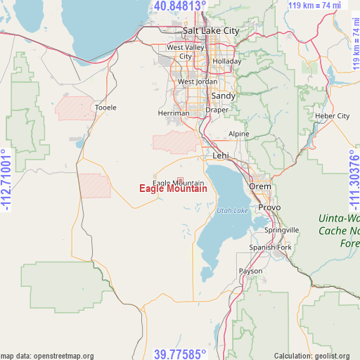
Eagle Mountain GPS coordinates[2]
40° 18' 50.832" North, 112° 0' 24.768" West
| Map corner | latitude | longitude |
|---|---|---|
| Upper-left | 40.84813°, | -112.71001° |
| Center: | 40.31412°, | -112.00688° |
| Lower-right: | 39.77585°, | -111.30376° |
| Map W x H: | 119.2×119.2 km | = 74.1×74.1mi |
| max Lat: | 71.29058° ⇑43.2% North |
| Eagle Mountain: | 40.31412° |
| min Lat: | ⇓56.8% South 19.06759° |
| min Long | Eagle Mountain | max Long |
| -171.73463° | -112.00688° | -66.98998° |
| W 12.5%⇐ | ⇒87.5% E |
Elevation
Elevation of Eagle Mountain is 1489 m = 4885 ft, and this is 1194.2 m = 3918 ft above average elevation for this country.
| Max E: |
3189 m = 10463 ft | 3.4% |
| Eagle Mountain | 1489 m 4885 ft | |
| Avg. | 294.8 m = 967 ft | |
Min E: |
-60 m = -197 ft | 96.6% |
See also: United States elevation on elevation.city.
Geographical zone
Eagle Mountain is located in North temperate zone (between Tropic of Cancer and the Arctic Circle). Distance of this Northern Tropic circle is 1876.6 km =1166.1 mi to South.| Distance of | km | miles | from Eagle Mountain |
|---|---|---|---|
| North Pole | 5524.6 | 3432.8 | to North |
| Arctic Circle | 2918.7 | 1813.6 | to North |
| Tropic Cancer | 1876.6 | 1166.1 | to South |
| Equator | 4482.5 | 2785.3 | to South |


Nearby cities:
15 places around Eagle Mountain: (largest is in red/bold)
• Alpine
24.8 km =15.4 mi,  51°
51°
• American Fork
19.2 km =11.9 mi,  68°
68°
• Bluffdale
20.4 km =12.7 mi,  16°
16°
• Cedar Hills
23.8 km =14.8 mi,  62°
62°
• Cedar Valley
6.6 km =4.1 mi,  288°
288°
• Draper
26.4 km =16.4 mi,  27°
27°
• Herriman
22.3 km =13.9 mi,  354°
354°
• Highland
21.8 km =13.5 mi, 55°
• Lehi
15.8 km =9.8 mi, 56°
• Lindon
24.5 km =15.2 mi,  82°
82°
• Orem
26.5 km =16.5 mi,  94°
94°
• Pleasant Grove
23.4 km =14.5 mi, 76°
• Riverton
23.8 km =14.8 mi,  13°
13°
• Saratoga Springs
9.5 km =5.9 mi, 65°
• Vineyard
22.1 km =13.7 mi, 94°
Sources, notices
• [Note1] Compared only with cities in United States existing in our database
• [Src1] Map data: © OpenStreetMap contributors (CC-BY-SA)
• [Src2] Other city data from geonames.org with taken over terms of usage.
• [Src3] Geographical zone / Annual Mean Temperature by Robert A. Rohde @ Wikipedia
