Honolulu geodata
Honolulu (Hawaii) is a seat of a first-order administrative division; located in United States in Pacific/Honolulu (GMT-10) time zone. With population of 371,657 people, there are 58 cities with bigger population in this country. Compared to other cities in United States, 99.7% of cities are located further ↑North; 99.5% of cities are located further →East and 89.1% of cities have higher elevation than Honolulu. Note1


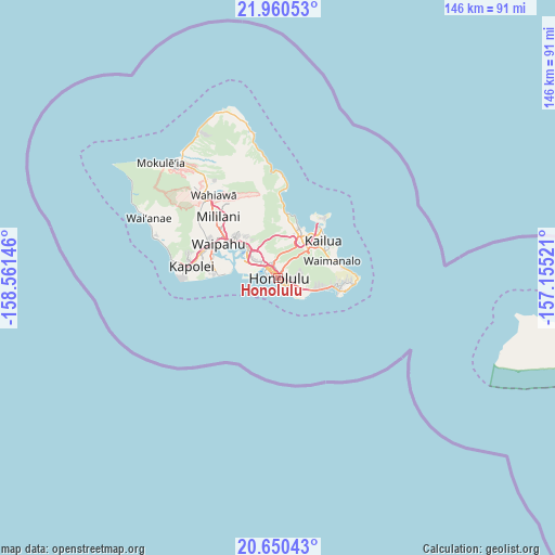
Honolulu GPS coordinates[2]
21° 18' 24.984" North, 157° 51' 29.988" West
| Map corner | latitude | longitude |
|---|---|---|
| Upper-left | 21.96053°, | -158.56146° |
| Center: | 21.30694°, | -157.85833° |
| Lower-right: | 20.65043°, | -157.15521° |
| Map W x H: | 145.7×145.7 km | = 90.5×90.5mi |
| max Lat: | 71.29058° ⇑99.7% North |
| Honolulu: | 21.30694° |
| min Lat: | ⇓0.3% South 19.06759° |
| min Long | Honolulu | max Long |
| -171.73463° | -157.85833° | -66.98998° |
| W 0.5%⇐ | ⇒99.5% E |
Elevation
Elevation of Honolulu is 18 m = 59 ft, and this is 276.8 m = 908 ft below average elevation for this country.
| Max E: |
3189 m = 10463 ft | 89.1% |
| Avg. | 294.8 m = 967 ft | |
| Honolulu | 18 m = 59 ft | |
Min E: |
-60 m = -197 ft | 10.9% |
See also: Honolulu elevation on elevation.city.
Geographical zone
Honolulu is located in North Torrid zone (between Equator and Tropic of Cancer). Distance of this Northern Tropic circle is 236.8 km =147.1 mi to North.| Distance of | km | miles | from Honolulu |
|---|---|---|---|
| North Pole | 7638 | 4746 | to North |
| Arctic Circle | 5032.1 | 3126.8 | to North |
| Tropic Cancer | 236.8 | 147.1 | to North |
| Equator | 2369.1 | 1472.1 | to South |


Nearby cities:
15 places around Honolulu: (largest is in red/bold)
• East Honolulu
14.7 km =9.1 mi,  97°
97°
• He‘eia
14.4 km =8.9 mi,  17°
17°
• Hickam Field
11.2 km =7 mi,  289°
289°
• Hālawa
10.4 km =6.5 mi,  320°
320°
• Hālawa Heights
9.8 km =6.1 mi, 324°
• Iroquois Point
13.1 km =8.1 mi,  280°
280°
• Kailua
16.2 km =10.1 mi,  48°
48°
• Kaneohe
12 km =7.5 mi,  30°
30°
• Maunawili
11.7 km =7.3 mi, 51°
• Pearl City
15.7 km =9.8 mi,  309°
309°
• Waimalu
14 km =8.7 mi, 321°
• Waimanalo
14.6 km =9.1 mi,  72°
72°
• ‘Aiea
11.4 km =7.1 mi, 317°
• ‘Ewa Beach
15.5 km =9.6 mi,  273°
273°
• ‘Āhuimanu
15.5 km =9.6 mi,  7°
7°
Sources, notices
• [Note1] Compared only with cities in United States existing in our database
• [Src1] Map data: © OpenStreetMap contributors (CC-BY-SA)
• [Src2] Other city data from geonames.org with taken over terms of usage.
• [Src3] Geographical zone / Annual Mean Temperature by Robert A. Rohde @ Wikipedia
