Waimanalo geodata
Waimanalo (Hawaii) is a seat of a third-order administrative division; located in United States in Pacific/Honolulu (GMT-10) time zone. With population of 5,451 people, there are 6805 cities with bigger population in this country. Compared to other cities in United States, 99.6% of cities are located further ↑North; 99.5% of cities are located further →East and 93.9% of cities have higher elevation than Waimanalo. Note1


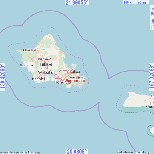
Waimanalo GPS coordinates[2]
21° 20' 46.104" North, 157° 43' 25.68" West
| Map corner | latitude | longitude |
|---|---|---|
| Upper-left | 21.99955°, | -158.42693° |
| Center: | 21.34614°, | -157.7238° |
| Lower-right: | 20.6898°, | -157.02068° |
| Map W x H: | 145.6×145.6 km | = 90.5×90.5mi |
| max Lat: | 71.29058° ⇑99.6% North |
| Waimanalo: | 21.34614° |
| min Lat: | ⇓0.4% South 19.06759° |
| min Long | Waimanalo | max Long |
| -171.73463° | -157.7238° | -66.98998° |
| W 0.5%⇐ | ⇒99.5% E |
Elevation
Elevation of Waimanalo is 10 m = 33 ft, and this is 284.8 m = 934 ft below average elevation for this country.
| Max E: |
3189 m = 10463 ft | 93.9% |
| Avg. | 294.8 m = 967 ft | |
| Waimanalo | 10 m = 33 ft | |
Min E: |
-60 m = -197 ft | 6.1% |
See also: United States elevation on elevation.city.
Geographical zone
Waimanalo is located in North Torrid zone (between Equator and Tropic of Cancer). Distance of this Northern Tropic circle is 232.5 km =144.5 mi to North.| Distance of | km | miles | from Waimanalo |
|---|---|---|---|
| North Pole | 7633.6 | 4743.3 | to North |
| Arctic Circle | 5027.7 | 3124.1 | to North |
| Tropic Cancer | 232.5 | 144.5 | to North |
| Equator | 2373.5 | 1474.8 | to South |


Nearby cities:
15 places around Waimanalo: (largest is in red/bold)
• East Honolulu
6.4 km =4 mi,  173°
173°
• He‘eia
13.4 km =8.3 mi,  314°
314°
• Honolulu
14.6 km =9.1 mi,  252°
252°
• Hālawa
20.8 km =12.9 mi,  280°
280°
• Hālawa Heights
20 km =12.4 mi, 280°
• Kahalu‘u
17.6 km =10.9 mi, 314°
• Kailua
6.5 km =4 mi,  344°
344°
• Kaneohe
9.8 km =6.1 mi, 307°
• Marine Corps Base Hawaii - MCBH
11.1 km =6.9 mi,  346°
346°
• Maunawili
5.7 km =3.5 mi,  301°
301°
• Waikane
21.3 km =13.2 mi,  321°
321°
• Waimalu
23.6 km =14.7 mi,  285°
285°
• Waimānalo Beach
2.8 km =1.7 mi,  118°
118°
• ‘Aiea
22.1 km =13.7 mi, 280°
• ‘Āhuimanu
16.1 km =10 mi, 312°
Sources, notices
• [Note1] Compared only with cities in United States existing in our database
• [Src1] Map data: © OpenStreetMap contributors (CC-BY-SA)
• [Src2] Other city data from geonames.org with taken over terms of usage.
• [Src3] Geographical zone / Annual Mean Temperature by Robert A. Rohde @ Wikipedia
