Mākaha Valley geodata
Mākaha Valley (Hawaii) is a populated place; located in United States in Pacific/Honolulu (GMT-10) time zone. With population of 1,341 people, there are 14386 cities with bigger population in this country. Compared to other cities in United States, 99.5% of cities are located further ↑North; 99.7% of cities are located further →East and 75.3% of cities have higher elevation than Mākaha Valley. Note1


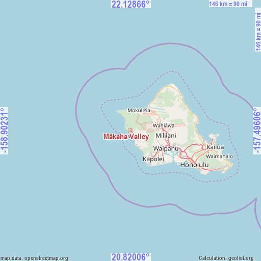
Mākaha Valley GPS coordinates[2]
21° 28' 32.988" North, 158° 11' 57.048" West
| Map corner | latitude | longitude |
|---|---|---|
| Upper-left | 22.12866°, | -158.90231° |
| Center: | 21.47583°, | -158.19918° |
| Lower-right: | 20.82006°, | -157.49606° |
| Map W x H: | 145.5×145.5 km | = 90.4×90.4mi |
| max Lat: | 71.29058° ⇑99.5% North |
| Mākaha Valley: | 21.47583° |
| min Lat: | ⇓0.5% South 19.06759° |
| min Long | Mākaha Valley | max Long |
| -171.73463° | -158.19918° | -66.98998° |
| W 0.3%⇐ | ⇒99.7% E |
Elevation
Elevation of Mākaha Valley is 70 m = 230 ft, and this is 224.8 m = 738 ft below average elevation for this country.
| Max E: |
3189 m = 10463 ft | 75.3% |
| Avg. | 294.8 m = 967 ft | |
| Mākaha Valley | 70 m = 230 ft | |
Min E: |
-60 m = -197 ft | 24.7% |
See also: United States elevation on elevation.city.
Geographical zone
Mākaha Valley is located in North Torrid zone (between Equator and Tropic of Cancer). Distance of this Northern Tropic circle is 218 km =135.5 mi to North.| Distance of | km | miles | from Mākaha Valley |
|---|---|---|---|
| North Pole | 7619.2 | 4734.3 | to North |
| Arctic Circle | 5013.3 | 3115.1 | to North |
| Tropic Cancer | 218 | 135.5 | to North |
| Equator | 2387.9 | 1483.8 | to South |


Nearby cities:
15 places around Mākaha Valley: (largest is in red/bold)
• Hale‘iwa
16.4 km =10.2 mi,  37°
37°
• Ko Olina
16.9 km =10.5 mi,  153°
153°
• Makakilo
18 km =11.2 mi,  139°
139°
• Makakilo City
18.5 km =11.5 mi, 140°
• Mokulēia
12.5 km =7.8 mi,  22°
22°
• Mākaha
1.6 km =1 mi,  227°
227°
• Mā‘ili
7.1 km =4.4 mi,  159°
159°
• Nānākuli
10.3 km =6.4 mi, 153°
• Schofield Barracks
14.1 km =8.8 mi,  79°
79°
• Village Park
19.5 km =12.1 mi,  116°
116°
• Wahiawā
18.3 km =11.4 mi, 80°
• Waialua
13.2 km =8.2 mi,  31°
31°
• Waianae
4.5 km =2.8 mi, 161°
• Waipi‘o Acres
19.3 km =12 mi,  93°
93°
• Whitmore Village
18.6 km =11.6 mi, 76°
Sources, notices
• [Note1] Compared only with cities in United States existing in our database
• [Src1] Map data: © OpenStreetMap contributors (CC-BY-SA)
• [Src2] Other city data from geonames.org with taken over terms of usage.
• [Src3] Geographical zone / Annual Mean Temperature by Robert A. Rohde @ Wikipedia
