Oltinko‘l geodata
Oltinko‘l (Andijon) is a seat of a second-order administrative division; located in Uzbekistan in Asia/Tashkent (GMT+5) time zone. In our database, there are 114 cities with bigger population. Compared to other cities in Uzbekistan, 58.6% of cities are located further ↓South; 93.7% of cities are located further ←West and 55.2% of cities have lower elevation than Oltinko‘l. Note1


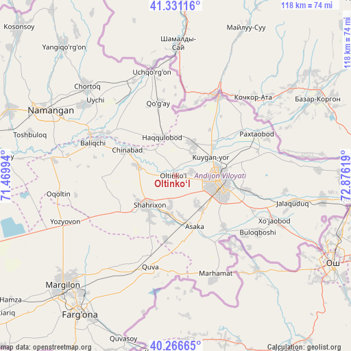
Oltinko‘l GPS coordinates[2]
40° 48' 3.744" North, 72° 10' 23.016" East
| Map corner | latitude | longitude |
|---|---|---|
| Upper-left | 41.33116°, | 71.46994° |
| Center: | 40.80104°, | 72.17306° |
| Lower-right: | 40.26665°, | 72.87619° |
| Map W x H: | 118.4×118.4 km | = 73.6×73.6mi |
| max Lat: | 43.77877° ⇑41.4% North |
| Oltinko‘l: | 40.80104° |
| min Lat: | ⇓58.6% South 37.22417° |
| min Long | Oltinko‘l | max Long |
| 58.84596° | 72.17306° | 72.76177° |
| W 93.7%⇐ | ⇒6.3% E |
Elevation
Elevation of Oltinko‘l is 444 m = 1457 ft, and this is 10.2 m = 33 ft above average elevation for this country.
| Max E: |
1464 m = 4803 ft | 44.8% |
| Oltinko‘l | 444 m 1457 ft | |
| Avg. | 433.8 m = 1423 ft | |
Min E: |
50 m = 164 ft | 55.2% |
See also: Uzbekistan elevation on elevation.city.
Geographical zone
Oltinko‘l is located in North temperate zone (between Tropic of Cancer and the Arctic Circle). Distance of this Northern Tropic circle is 1930.7 km =1199.7 mi to South.| Distance of | km | miles | from Oltinko‘l |
|---|---|---|---|
| North Pole | 5470.4 | 3399.1 | to North |
| Arctic Circle | 2864.5 | 1779.9 | to North |
| Tropic Cancer | 1930.7 | 1199.7 | to South |
| Equator | 4536.7 | 2819 | to South |


Nearby cities:
15 places around Oltinko‘l: (largest is in red/bold)
• Andijon
14.6 km =9.1 mi,  98°
98°
• Asaka
18.6 km =11.6 mi,  162°
162°
• Baliqchi
29.7 km =18.5 mi,  292°
292°
• Buloqboshi
33.7 km =20.9 mi,  124°
124°
• Haqqulobod
13.7 km =8.5 mi,  339°
339°
• Kuyganyor
12.8 km =8 mi,  62°
62°
• Marhamat
35.6 km =22.1 mi, 158°
• Marhamat
37.6 km =23.4 mi, 161°
• Paxtaobod
30.7 km =19.1 mi, 62°
• Poytug‘
12.3 km =7.6 mi,  29°
29°
• Quva
32.2 km =20 mi,  195°
195°
• Shahrixon
13.8 km =8.6 mi,  225°
225°
• Uchqŭrghon Shahri
35.6 km =22.1 mi,  347°
347°
• Uychi
37.5 km =23.3 mi,  325°
325°
• Xo‘jaobod
35.8 km =22.2 mi,  114°
114°
Sources, notices
• [Note1] Compared only with cities in Uzbekistan existing in our database
• [Src1] Map data: © OpenStreetMap contributors (CC-BY-SA)
• [Src2] Other city data from geonames.org with taken over terms of usage.
• [Src3] Geographical zone / Annual Mean Temperature by Robert A. Rohde @ Wikipedia
