Tashkent geodata
Tashkent (Toshkent Shahri) is a capital of a political entity; located in Uzbekistan in Asia/Tashkent (GMT+5) time zone. With population of 1,978,028 people, there are 0 cities with bigger population in this country. Compared to other cities in Uzbekistan, 78.7% of cities are located further ↓South; 60.3% of cities are located further ←West and 51.7% of cities have lower elevation than Tashkent. Note1


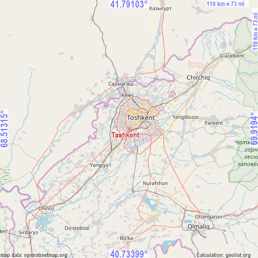
Tashkent GPS coordinates[2]
41° 15' 52.74" North, 69° 12' 58.572" East
| Map corner | latitude | longitude |
|---|---|---|
| Upper-left | 41.79103°, | 68.51315° |
| Center: | 41.26465°, | 69.21627° |
| Lower-right: | 40.73399°, | 69.9194° |
| Map W x H: | 117.5×117.5 km | = 73×73mi |
| max Lat: | 43.77877° ⇑21.3% North |
| Tashkent: | 41.26465° |
| min Lat: | ⇓78.7% South 37.22417° |
| min Long | Tashkent | max Long |
| 58.84596° | 69.21627° | 72.76177° |
| W 60.3%⇐ | ⇒39.7% E |
Elevation
Elevation of Tashkent is 424 m = 1391 ft, and this is 9.8 m = 32 ft below average elevation for this country.
| Max E: |
1464 m = 4803 ft | 48.3% |
| Avg. | 433.8 m = 1423 ft | |
| Tashkent | 424 m = 1391 ft | |
Min E: |
50 m = 164 ft | 51.7% |
See also: Tashkent elevation on elevation.city.
Geographical zone
Tashkent is located in North temperate zone (between Tropic of Cancer and the Arctic Circle). Distance of this Northern Tropic circle is 1982.3 km =1231.7 mi to South.| Distance of | km | miles | from Tashkent |
|---|---|---|---|
| North Pole | 5418.9 | 3367.1 | to North |
| Arctic Circle | 2813 | 1747.9 | to North |
| Tropic Cancer | 1982.3 | 1231.7 | to South |
| Equator | 4588.2 | 2851 | to South |


Nearby cities:
15 places around Tashkent: (largest is in red/bold)
• Amir Timur
35.7 km =22.2 mi,  220°
220°
• Bektemir
11.6 km =7.2 mi,  121°
121°
• Bo‘ka
50.5 km =31.4 mi,  182°
182°
• Chinoz
52.8 km =32.8 mi,  226°
226°
• Chirchiq
38.1 km =23.7 mi,  53°
53°
• Iskandar
51.6 km =32.1 mi, 51°
• Parkent
38.6 km =24 mi,  85°
85°
• Piskent
42.4 km =26.3 mi,  164°
164°
• Qibray
25 km =15.5 mi,  56°
56°
• Salor
18.3 km =11.4 mi, 49°
• Sŭqoq
48.5 km =30.1 mi, 92°
• Tŭytepa
28.6 km =17.8 mi,  154°
154°
• Yangiyŭl
22.1 km =13.7 mi, 219°
• Zafar
41 km =25.5 mi, 220°
• Ŭrtaowul
10.5 km =6.5 mi,  214°
214°
In other languages:
- In Spanish: Taskent
- In France: Tachkent
- In German: Taschkent
- In Italian: Taskent
- In Russian: Ташкент
- In Chinese: 塔什干
Sources, notices
• [Note1] Compared only with cities in Uzbekistan existing in our database
• [Src1] Map data: © OpenStreetMap contributors (CC-BY-SA)
• [Src2] Other city data from geonames.org with taken over terms of usage.
• [Src3] Geographical zone / Annual Mean Temperature by Robert A. Rohde @ Wikipedia
