Tŭytepa geodata
Tŭytepa (Toshkent) is a populated place; located in Uzbekistan in Asia/Tashkent (GMT+5) time zone. With population of 20,682 people, there are 80 cities with bigger population in this country. Compared to other cities in Uzbekistan, 71.3% of cities are located further ↓South; 62.6% of cities are located further ←West and 55.7% of cities have higher elevation than Tŭytepa. Note1


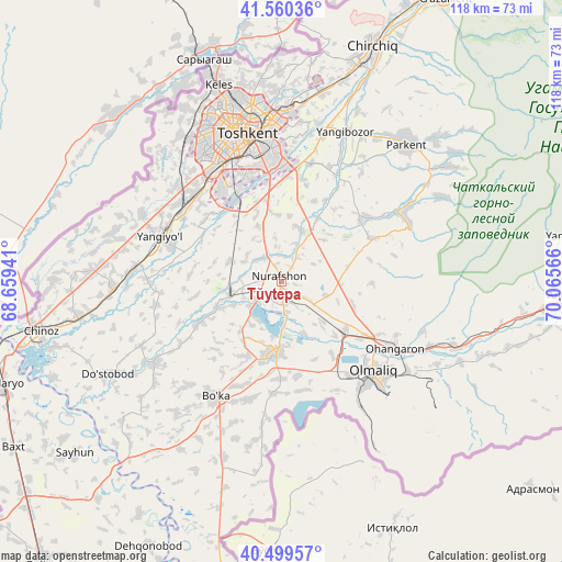
Tŭytepa GPS coordinates[2]
41° 1' 55.56" North, 69° 21' 45.108" East
| Map corner | latitude | longitude |
|---|---|---|
| Upper-left | 41.56036°, | 68.65941° |
| Center: | 41.0321°, | 69.36253° |
| Lower-right: | 40.49957°, | 70.06566° |
| Map W x H: | 117.9×117.9 km | = 73.3×73.3mi |
| max Lat: | 43.77877° ⇑28.7% North |
| Tŭytepa: | 41.0321° |
| min Lat: | ⇓71.3% South 37.22417° |
| min Long | Tŭytepa | max Long |
| 58.84596° | 69.36253° | 72.76177° |
| W 62.6%⇐ | ⇒37.4% E |
Elevation
Elevation of Tŭytepa is 395 m = 1296 ft, and this is 38.8 m = 127 ft below average elevation for this country.
| Max E: |
1464 m = 4803 ft | 55.7% |
| Avg. | 433.8 m = 1423 ft | |
| Tŭytepa | 395 m = 1296 ft | |
Min E: |
50 m = 164 ft | 44.3% |
See also: Uzbekistan elevation on elevation.city.
Geographical zone
Tŭytepa is located in North temperate zone (between Tropic of Cancer and the Arctic Circle). Distance of this Northern Tropic circle is 1956.4 km =1215.7 mi to South.| Distance of | km | miles | from Tŭytepa |
|---|---|---|---|
| North Pole | 5444.7 | 3383.2 | to North |
| Arctic Circle | 2838.8 | 1763.9 | to North |
| Tropic Cancer | 1956.4 | 1215.7 | to South |
| Equator | 4562.3 | 2834.9 | to South |


Nearby cities:
15 places around Tŭytepa: (largest is in red/bold)
• Amir Timur
35.4 km =22 mi,  267°
267°
• Bektemir
19.9 km =12.4 mi,  353°
353°
• Bo‘ka
28.4 km =17.6 mi,  209°
209°
• Chinoz
51.6 km =32.1 mi,  258°
258°
• Ohangaron
27 km =16.8 mi,  121°
121°
• Olmaliq
28.7 km =17.8 mi,  136°
136°
• Parkent
39.3 km =24.4 mi,  42°
42°
• Piskent
15 km =9.3 mi,  183°
183°
• Qibray
40.7 km =25.3 mi,  12°
12°
• Salor
37.9 km =23.5 mi,  2°
2°
• Sŭqoq
43.6 km =27.1 mi,  56°
56°
• Tashkent
28.6 km =17.8 mi,  334°
334°
• Yangiyŭl
27.9 km =17.3 mi,  288°
288°
• Zafar
39.2 km =24.4 mi, 262°
• Ŭrtaowul
25 km =15.5 mi,  313°
313°
Sources, notices
• [Note1] Compared only with cities in Uzbekistan existing in our database
• [Src1] Map data: © OpenStreetMap contributors (CC-BY-SA)
• [Src2] Other city data from geonames.org with taken over terms of usage.
• [Src3] Geographical zone / Annual Mean Temperature by Robert A. Rohde @ Wikipedia
