Amir Timur geodata
Amir Timur (Toshkent) is a seat of a first-order administrative division; located in Uzbekistan in Asia/Tashkent (GMT+5) time zone. In our database, there are 114 cities with bigger population. Compared to other cities in Uzbekistan, 70.7% of cities are located further ↓South; 58% of cities are located further ←West and 66.7% of cities have higher elevation than Amir Timur. Note1


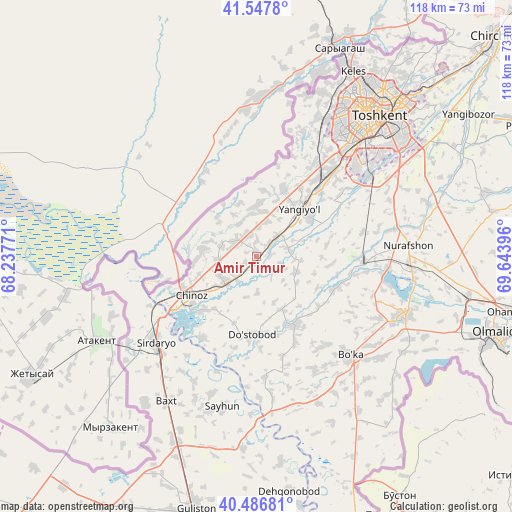
Amir Timur GPS coordinates[2]
41° 1' 9.984" North, 68° 56' 26.988" East
| Map corner | latitude | longitude |
|---|---|---|
| Upper-left | 41.5478°, | 68.23771° |
| Center: | 41.01944°, | 68.94083° |
| Lower-right: | 40.48681°, | 69.64396° |
| Map W x H: | 118×118 km | = 73.3×73.3mi |
| max Lat: | 43.77877° ⇑29.3% North |
| Amir Timur: | 41.01944° |
| min Lat: | ⇓70.7% South 37.22417° |
| min Long | Amir Timur | max Long |
| 58.84596° | 68.94083° | 72.76177° |
| W 58%⇐ | ⇒42% E |
Elevation
Elevation of Amir Timur is 319 m = 1047 ft, and this is 114.8 m = 377 ft below average elevation for this country.
| Max E: |
1464 m = 4803 ft | 66.7% |
| Avg. | 433.8 m = 1423 ft | |
| Amir Timur | 319 m = 1047 ft | |
Min E: |
50 m = 164 ft | 33.3% |
See also: Uzbekistan elevation on elevation.city.
Geographical zone
Amir Timur is located in North temperate zone (between Tropic of Cancer and the Arctic Circle). Distance of this Northern Tropic circle is 1955 km =1214.8 mi to South.| Distance of | km | miles | from Amir Timur |
|---|---|---|---|
| North Pole | 5446.1 | 3384 | to North |
| Arctic Circle | 2840.2 | 1764.8 | to North |
| Tropic Cancer | 1955 | 1214.8 | to South |
| Equator | 4560.9 | 2834 | to South |


Nearby cities:
15 places around Amir Timur: (largest is in red/bold)
• Bektemir
39.2 km =24.4 mi,  57°
57°
• Bo‘ka
31.5 km =19.6 mi,  137°
137°
• Chinoz
17.7 km =11 mi,  238°
238°
• Guliston
60.4 km =37.5 mi,  192°
192°
• Ohangaron
59.9 km =37.2 mi,  102°
102°
• Olmaliq
58.5 km =36.4 mi,  109°
109°
• Piskent
37 km =23 mi, 111°
• Qibray
60.1 km =37.3 mi,  46°
46°
• Salor
53.8 km =33.4 mi,  43°
43°
• Sirdaryo
30.5 km =19 mi,  230°
230°
• Tashkent
35.7 km =22.2 mi, 40°
• Tŭytepa
35.4 km =22 mi,  87°
87°
• Yangiyŭl
13.6 km =8.5 mi, 40°
• Zafar
5.3 km =3.3 mi,  220°
220°
• Ŭrtaowul
25.3 km =15.7 mi, 42°
Sources, notices
• [Note1] Compared only with cities in Uzbekistan existing in our database
• [Src1] Map data: © OpenStreetMap contributors (CC-BY-SA)
• [Src2] Other city data from geonames.org with taken over terms of usage.
• [Src3] Geographical zone / Annual Mean Temperature by Robert A. Rohde @ Wikipedia
