Yangiyŭl geodata
Yangiyŭl (Toshkent) is a populated place; located in Uzbekistan in Asia/Tashkent (GMT+5) time zone. With population of 60,000 people, there are 21 cities with bigger population in this country. Compared to other cities in Uzbekistan, 73.6% of cities are located further ↓South; 58.6% of cities are located further ←West and 63.2% of cities have higher elevation than Yangiyŭl. Note1


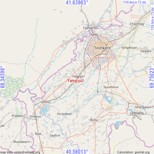
Yangiyŭl GPS coordinates[2]
41° 6' 43.272" North, 69° 2' 49.56" East
| Map corner | latitude | longitude |
|---|---|---|
| Upper-left | 41.63963°, | 68.34398° |
| Center: | 41.11202°, | 69.0471° |
| Lower-right: | 40.58013°, | 69.75023° |
| Map W x H: | 117.8×117.8 km | = 73.2×73.2mi |
| max Lat: | 43.77877° ⇑26.4% North |
| Yangiyŭl: | 41.11202° |
| min Lat: | ⇓73.6% South 37.22417° |
| min Long | Yangiyŭl | max Long |
| 58.84596° | 69.0471° | 72.76177° |
| W 58.6%⇐ | ⇒41.4% E |
Elevation
Elevation of Yangiyŭl is 347 m = 1138 ft, and this is 86.8 m = 285 ft below average elevation for this country.
| Max E: |
1464 m = 4803 ft | 63.2% |
| Avg. | 433.8 m = 1423 ft | |
| Yangiyŭl | 347 m = 1138 ft | |
Min E: |
50 m = 164 ft | 36.8% |
See also: Yangiyŭl elevation on elevation.city.
Geographical zone
Yangiyŭl is located in North temperate zone (between Tropic of Cancer and the Arctic Circle). Distance of this Northern Tropic circle is 1965.3 km =1221.2 mi to South.| Distance of | km | miles | from Yangiyŭl |
|---|---|---|---|
| North Pole | 5435.8 | 3377.6 | to North |
| Arctic Circle | 2829.9 | 1758.4 | to North |
| Tropic Cancer | 1965.3 | 1221.2 | to South |
| Equator | 4571.2 | 2840.4 | to South |


Nearby cities:
15 places around Yangiyŭl: (largest is in red/bold)
• Amir Timur
13.6 km =8.5 mi,  220°
220°
• Bektemir
26.4 km =16.4 mi,  65°
65°
• Bo‘ka
35.7 km =22.2 mi,  159°
159°
• Chinoz
30.9 km =19.2 mi,  230°
230°
• Ohangaron
54.6 km =33.9 mi,  114°
114°
• Olmaliq
55 km =34.2 mi,  122°
122°
• Parkent
56.4 km =35 mi, 68°
• Piskent
34.9 km =21.7 mi,  133°
133°
• Qibray
46.6 km =29 mi,  48°
48°
• Salor
40.2 km =25 mi,  44°
44°
• Sirdaryo
44 km =27.3 mi, 227°
• Tashkent
22.1 km =13.7 mi, 39°
• Tŭytepa
27.9 km =17.3 mi, 108°
• Zafar
18.9 km =11.7 mi, 220°
• Ŭrtaowul
11.7 km =7.3 mi, 44°
Sources, notices
• [Note1] Compared only with cities in Uzbekistan existing in our database
• [Src1] Map data: © OpenStreetMap contributors (CC-BY-SA)
• [Src2] Other city data from geonames.org with taken over terms of usage.
• [Src3] Geographical zone / Annual Mean Temperature by Robert A. Rohde @ Wikipedia
