Salor geodata
Salor (Toshkent) is a populated place; located in Uzbekistan in Asia/Tashkent (GMT+5) time zone. With population of 26,494 people, there are 61 cities with bigger population in this country. Compared to other cities in Uzbekistan, 80.5% of cities are located further ↓South; 63.2% of cities are located further ←West and 68.4% of cities have lower elevation than Salor. Note1


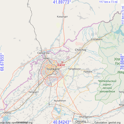
Salor GPS coordinates[2]
41° 22' 19.992" North, 69° 22' 54.012" East
| Map corner | latitude | longitude |
|---|---|---|
| Upper-left | 41.89773°, | 68.67855° |
| Center: | 41.37222°, | 69.38167° |
| Lower-right: | 40.84243°, | 70.0848° |
| Map W x H: | 117.3×117.3 km | = 72.9×72.9mi |
| max Lat: | 43.77877° ⇑19.5% North |
| Salor: | 41.37222° |
| min Lat: | ⇓80.5% South 37.22417° |
| min Long | Salor | max Long |
| 58.84596° | 69.38167° | 72.76177° |
| W 63.2%⇐ | ⇒36.8% E |
Elevation
Elevation of Salor is 516 m = 1693 ft, and this is 82.2 m = 270 ft above average elevation for this country.
| Max E: |
1464 m = 4803 ft | 31.6% |
| Salor | 516 m 1693 ft | |
| Avg. | 433.8 m = 1423 ft | |
Min E: |
50 m = 164 ft | 68.4% |
See also: Uzbekistan elevation on elevation.city.
Geographical zone
Salor is located in North temperate zone (between Tropic of Cancer and the Arctic Circle). Distance of this Northern Tropic circle is 1994.2 km =1239.1 mi to South.| Distance of | km | miles | from Salor |
|---|---|---|---|
| North Pole | 5406.9 | 3359.7 | to North |
| Arctic Circle | 2801 | 1740.5 | to North |
| Tropic Cancer | 1994.2 | 1239.1 | to South |
| Equator | 4600.2 | 2858.4 | to South |


Nearby cities:
15 places around Salor: (largest is in red/bold)
• Amir Timur
53.8 km =33.4 mi,  223°
223°
• Bektemir
18.5 km =11.5 mi,  192°
192°
• Chirchiq
19.9 km =12.4 mi,  57°
57°
• G‘azalkent
38.4 km =23.9 mi, 57°
• Iskandar
33.4 km =20.8 mi,  52°
52°
• Kyzyldzhar
57.2 km =35.5 mi,  67°
67°
• Ohangaron
56.1 km =34.9 mi,  157°
157°
• Parkent
26.1 km =16.2 mi,  109°
109°
• Piskent
52.9 km =32.9 mi,  182°
182°
• Qibray
7.2 km =4.5 mi, 74°
• Sŭqoq
37.3 km =23.2 mi, 111°
• Tashkent
18.3 km =11.4 mi,  229°
229°
• Tŭytepa
37.9 km =23.5 mi, 182°
• Yangiyŭl
40.2 km =25 mi, 224°
• Ŭrtaowul
28.6 km =17.8 mi, 223°
Sources, notices
• [Note1] Compared only with cities in Uzbekistan existing in our database
• [Src1] Map data: © OpenStreetMap contributors (CC-BY-SA)
• [Src2] Other city data from geonames.org with taken over terms of usage.
• [Src3] Geographical zone / Annual Mean Temperature by Robert A. Rohde @ Wikipedia
