Fergana geodata
Fergana is a seat of a first-order administrative division; located in Uzbekistan in Asia/Tashkent (GMT+5) time zone. With population of 164,322 people, there are 9 cities with bigger population in this country. Compared to other cities in Uzbekistan, 59.8% of cities are located further ↑North; 87.4% of cities are located further ←West and 78.2% of cities have lower elevation than Fergana. Note1


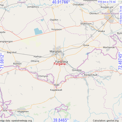
Fergana GPS coordinates[2]
40° 23' 3.156" North, 71° 47' 3.552" East
| Map corner | latitude | longitude |
|---|---|---|
| Upper-left | 40.91766°, | 71.0812° |
| Center: | 40.38421°, | 71.78432° |
| Lower-right: | 39.8465°, | 72.48745° |
| Map W x H: | 119.1×119.1 km | = 74×74mi |
| max Lat: | 43.77877° ⇑59.8% North |
| Fergana: | 40.38421° |
| min Lat: | ⇓40.2% South 37.22417° |
| min Long | Fergana | max Long |
| 58.84596° | 71.78432° | 72.76177° |
| W 87.4%⇐ | ⇒12.6% E |
Elevation
Elevation of Fergana is 580 m = 1903 ft, and this is 146.2 m = 480 ft above average elevation for this country.
| Max E: |
1464 m = 4803 ft | 21.8% |
| Fergana | 580 m 1903 ft | |
| Avg. | 433.8 m = 1423 ft | |
Min E: |
50 m = 164 ft | 78.2% |
See also: Fergana elevation on elevation.city.
Geographical zone
Fergana is located in North temperate zone (between Tropic of Cancer and the Arctic Circle). Distance of this Northern Tropic circle is 1884.4 km =1170.9 mi to South.| Distance of | km | miles | from Fergana |
|---|---|---|---|
| North Pole | 5516.8 | 3428 | to North |
| Arctic Circle | 2910.9 | 1808.7 | to North |
| Tropic Cancer | 1884.4 | 1170.9 | to South |
| Equator | 4490.3 | 2790.1 | to South |


Nearby cities:
15 places around Fergana: (largest is in red/bold)
• Hamza
24.1 km =15 mi,  281°
281°
• Kirguli
5.9 km =3.7 mi,  345°
345°
• Langar
18.4 km =11.4 mi,  325°
325°
• Marg‘ilon
11 km =6.8 mi, 332°
• Oltiariq
26.3 km =16.3 mi,  271°
271°
• Oqoltin
40.9 km =25.4 mi, 350°
• Quva
28.8 km =17.9 mi,  57°
57°
• Quvasoy
19.2 km =11.9 mi,  120°
120°
• Rishton
42.4 km =26.3 mi, 265°
• Shahrixon
43.2 km =26.8 mi,  32°
32°
• Shohimardon
44.6 km =27.7 mi,  177°
177°
• Toshloq
10.4 km =6.5 mi, 352°
• Vodil
23.8 km =14.8 mi,  191°
191°
• Yangi Marg‘ilon
7.3 km =4.5 mi,  310°
310°
• Yozyovon
31 km =19.3 mi, 353°
In other languages:
- In Spanish: Ferganá
- In France: Ferghana
- In German: Fargʻona
- In Russian: Фергана
- In Chinese: 费尔干纳
Sources, notices
• [Note1] Compared only with cities in Uzbekistan existing in our database
• [Src1] Map data: © OpenStreetMap contributors (CC-BY-SA)
• [Src2] Other city data from geonames.org with taken over terms of usage.
• [Src3] Geographical zone / Annual Mean Temperature by Robert A. Rohde @ Wikipedia
