Quva geodata
Quva (Fergana) is a seat of a second-order administrative division; located in Uzbekistan in Asia/Tashkent (GMT+5) time zone. With population of 33,167 people, there are 41 cities with bigger population in this country. Compared to other cities in Uzbekistan, 51.7% of cities are located further ↑North; 92% of cities are located further ←West and 65.5% of cities have lower elevation than Quva. Note1


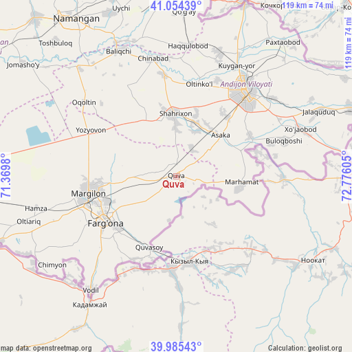
Quva GPS coordinates[2]
40° 31' 19.344" North, 72° 4' 22.512" East
| Map corner | latitude | longitude |
|---|---|---|
| Upper-left | 41.05439°, | 71.3698° |
| Center: | 40.52204°, | 72.07292° |
| Lower-right: | 39.98543°, | 72.77605° |
| Map W x H: | 118.9×118.9 km | = 73.9×73.9mi |
| max Lat: | 43.77877° ⇑51.7% North |
| Quva: | 40.52204° |
| min Lat: | ⇓48.3% South 37.22417° |
| min Long | Quva | max Long |
| 58.84596° | 72.07292° | 72.76177° |
| W 92%⇐ | ⇒8% E |
Elevation
Elevation of Quva is 496 m = 1627 ft, and this is 62.2 m = 204 ft above average elevation for this country.
| Max E: |
1464 m = 4803 ft | 34.5% |
| Quva | 496 m 1627 ft | |
| Avg. | 433.8 m = 1423 ft | |
Min E: |
50 m = 164 ft | 65.5% |
See also: Uzbekistan elevation on elevation.city.
Geographical zone
Quva is located in North temperate zone (between Tropic of Cancer and the Arctic Circle). Distance of this Northern Tropic circle is 1899.7 km =1180.4 mi to South.| Distance of | km | miles | from Quva |
|---|---|---|---|
| North Pole | 5501.4 | 3418.4 | to North |
| Arctic Circle | 2895.5 | 1799.2 | to North |
| Tropic Cancer | 1899.7 | 1180.4 | to South |
| Equator | 4505.6 | 2799.6 | to South |


Nearby cities:
15 places around Quva: (largest is in red/bold)
• Andijon
36.9 km =22.9 mi,  38°
38°
• Asaka
19.3 km =12 mi,  46°
46°
• Buloqboshi
38.2 km =23.7 mi,  71°
71°
• Fergana
28.8 km =17.9 mi,  237°
237°
• Kirguli
27.6 km =17.1 mi,  249°
249°
• Langar
34.9 km =21.7 mi,  269°
269°
• Marg‘ilon
30 km =18.6 mi,  259°
259°
• Marhamat
20.9 km =13 mi,  102°
102°
• Marhamat
21.5 km =13.4 mi, 95°
• Oltinko‘l
32.2 km =20 mi,  15°
15°
• Quvasoy
26.2 km =16.3 mi,  197°
197°
• Shahrixon
21.3 km =13.2 mi,  356°
356°
• Toshloq
26.3 km =16.3 mi, 259°
• Yangi Marg‘ilon
31.7 km =19.7 mi, 250°
• Yozyovon
31.8 km =19.8 mi,  299°
299°
Sources, notices
• [Note1] Compared only with cities in Uzbekistan existing in our database
• [Src1] Map data: © OpenStreetMap contributors (CC-BY-SA)
• [Src2] Other city data from geonames.org with taken over terms of usage.
• [Src3] Geographical zone / Annual Mean Temperature by Robert A. Rohde @ Wikipedia
