Quvasoy geodata
Quvasoy (Fergana) is a seat of a second-order administrative division; located in Uzbekistan in Asia/Bishkek (GMT+6) time zone. With population of 32,024 people, there are 43 cities with bigger population in this country. Compared to other cities in Uzbekistan, 62.1% of cities are located further ↑North; 90.8% of cities are located further ←West and 93.1% of cities have lower elevation than Quvasoy. Note1


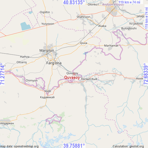
Quvasoy GPS coordinates[2]
40° 17' 49.956" North, 71° 58' 48.936" East
| Map corner | latitude | longitude |
|---|---|---|
| Upper-left | 40.83135°, | 71.27714° |
| Center: | 40.29721°, | 71.98026° |
| Lower-right: | 39.75881°, | 72.68339° |
| Map W x H: | 119.3×119.3 km | = 74.1×74.1mi |
| max Lat: | 43.77877° ⇑62.1% North |
| Quvasoy: | 40.29721° |
| min Lat: | ⇓37.9% South 37.22417° |
| min Long | Quvasoy | max Long |
| 58.84596° | 71.98026° | 72.76177° |
| W 90.8%⇐ | ⇒9.2% E |
Elevation
Elevation of Quvasoy is 815 m = 2674 ft, and this is 381.2 m = 1251 ft above average elevation for this country.
| Max E: |
1464 m = 4803 ft | 6.9% |
| Quvasoy | 815 m 2674 ft | |
| Avg. | 433.8 m = 1423 ft | |
Min E: |
50 m = 164 ft | 93.1% |
See also: Uzbekistan elevation on elevation.city.
Geographical zone
Quvasoy is located in North temperate zone (between Tropic of Cancer and the Arctic Circle). Distance of this Northern Tropic circle is 1874.7 km =1164.9 mi to South.| Distance of | km | miles | from Quvasoy |
|---|---|---|---|
| North Pole | 5526.4 | 3433.9 | to North |
| Arctic Circle | 2920.5 | 1814.7 | to North |
| Tropic Cancer | 1874.7 | 1164.9 | to South |
| Equator | 4480.6 | 2784.1 | to South |


Nearby cities:
15 places around Quvasoy: (largest is in red/bold)
• Asaka
44.1 km =27.4 mi,  29°
29°
• Fergana
19.2 km =11.9 mi,  300°
300°
• Hamza
42.8 km =26.6 mi,  289°
289°
• Kirguli
23.7 km =14.7 mi,  310°
310°
• Langar
36.8 km =22.9 mi, 312°
• Marg‘ilon
29.1 km =18.1 mi, 311°
• Marhamat
34.8 km =21.6 mi,  54°
54°
• Marhamat
37.1 km =23.1 mi, 52°
• Oltiariq
44.2 km =27.5 mi,  283°
283°
• Quva
26.2 km =16.3 mi,  17°
17°
• Shohimardon
38 km =23.6 mi,  203°
203°
• Toshloq
26.9 km =16.7 mi,  318°
318°
• Vodil
25.3 km =15.7 mi,  237°
237°
• Yangi Marg‘ilon
26.4 km =16.4 mi, 303°
• Yozyovon
45.2 km =28.1 mi,  333°
333°
Sources, notices
• [Note1] Compared only with cities in Uzbekistan existing in our database
• [Src1] Map data: © OpenStreetMap contributors (CC-BY-SA)
• [Src2] Other city data from geonames.org with taken over terms of usage.
• [Src3] Geographical zone / Annual Mean Temperature by Robert A. Rohde @ Wikipedia
