Calderas geodata
Calderas (Barinas) is a seat of a third-order administrative division; located in Venezuela in America/Caracas (GMT-4) time zone. In our database, there are 108 cities with bigger population. Compared to other cities in Venezuela, 65.6% of cities are located further ↑North; 72% of cities are located further →East and 86.5% of cities have lower elevation than Calderas. Note1


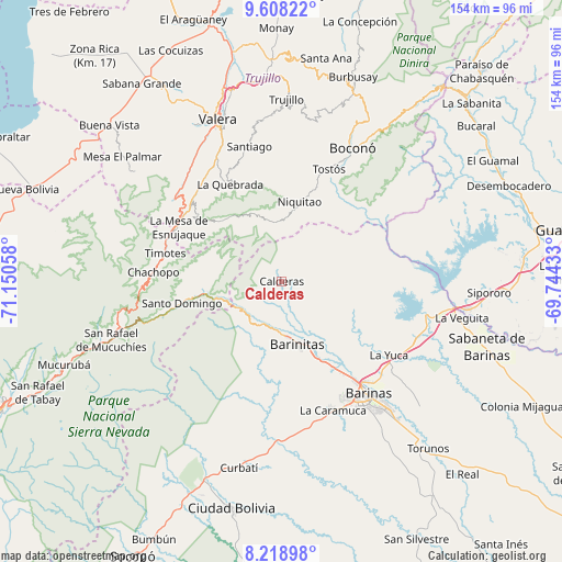
Calderas GPS coordinates[2]
8° 54' 51.336" North, 70° 26' 50.82" West
| Map corner | latitude | longitude |
|---|---|---|
| Upper-left | 9.60822°, | -71.15058° |
| Center: | 8.91426°, | -70.44745° |
| Lower-right: | 8.21898°, | -69.74433° |
| Map W x H: | 154.5×154.5 km | = 96×96mi |
| max Lat: | 11.94788° ⇑65.6% North |
| Calderas: | 8.91426° |
| min Lat: | ⇓34.4% South 1.92027° |
| min Long | Calderas | max Long |
| -72.55212° | -70.44745° | -60.99778° |
| W 28%⇐ | ⇒72% E |
Elevation
Elevation of Calderas is 908 m = 2979 ft, and this is 527.4 m = 1730 ft above average elevation for this country.
| Max E: |
2986 m = 9797 ft | 13.5% |
| Calderas | 908 m 2979 ft | |
| Avg. | 380.6 m = 1249 ft | |
Min E: |
-4 m = -13 ft | 86.5% |
See also: Venezuela elevation on elevation.city.
Geographical zone
Calderas is located in North Torrid zone (between Equator and Tropic of Cancer). Distance of Equator is 991.2 km =615.9 mi to South.| Distance of | km | miles | from Calderas |
|---|---|---|---|
| North Pole | 9015.9 | 5602.2 | to North |
| Arctic Circle | 6410 | 3983 | to North |
| Tropic Cancer | 1614.7 | 1003.3 | to North |
| Equator | 991.2 | 615.9 | to South |


Nearby cities:
15 places around Calderas: (largest is in red/bold)
• Altamira
11.8 km =7.3 mi,  210°
210°
• Barinas
41.8 km =26 mi,  140°
140°
• Barinitas
17.4 km =10.8 mi,  167°
167°
• Barrancas
40.3 km =25 mi,  113°
113°
• Caramuca
37.9 km =23.5 mi,  158°
158°
• El Corozo
39.8 km =24.7 mi, 165°
• La Mula
39 km =24.2 mi, 168°
• La Quebrada
30.3 km =18.8 mi,  332°
332°
• La Yuca
35.7 km =22.2 mi,  124°
124°
• Los Guasimitos
36.5 km =22.7 mi, 139°
• Masparrito
18.8 km =11.7 mi,  58°
58°
• Pueblo Llano
23.3 km =14.5 mi,  270°
270°
• Quebrada Seca
27.7 km =17.2 mi,  149°
149°
• Santo Domingo
27.8 km =17.3 mi,  257°
257°
• Timotes
32.9 km =20.4 mi,  283°
283°
Sources, notices
• [Note1] Compared only with cities in Venezuela existing in our database
• [Src1] Map data: © OpenStreetMap contributors (CC-BY-SA)
• [Src2] Other city data from geonames.org with taken over terms of usage.
• [Src3] Geographical zone / Annual Mean Temperature by Robert A. Rohde @ Wikipedia
