Valle de La Pascua geodata
Valle de La Pascua (Guárico) is a seat of a second-order administrative division; located in Venezuela in America/Caracas (GMT-4) time zone. With population of 89,080 people, there are 46 cities with bigger population in this country. Compared to other cities in Venezuela, 59.8% of cities are located further ↑North; 78.6% of cities are located further ←West and 52.7% of cities have lower elevation than Valle de La Pascua. Note1


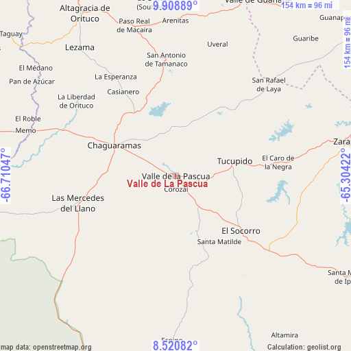
Valle de La Pascua GPS coordinates[2]
9° 12' 55.944" North, 66° 0' 26.424" West
| Map corner | latitude | longitude |
|---|---|---|
| Upper-left | 9.90889°, | -66.71047° |
| Center: | 9.21554°, | -66.00734° |
| Lower-right: | 8.52082°, | -65.30422° |
| Map W x H: | 154.3×154.3 km | = 95.9×95.9mi |
| max Lat: | 11.94788° ⇑59.8% North |
| Valle de La Pascua: | 9.21554° |
| min Lat: | ⇓40.2% South 1.92027° |
| min Long | Valle de La Pas | max Long |
| -72.55212° | -66.00734° | -60.99778° |
| W 78.6%⇐ | ⇒21.4% E |
Elevation
Elevation of Valle de La Pascua is 189 m = 620 ft, and this is 191.6 m = 629 ft below average elevation for this country.
| Max E: |
2986 m = 9797 ft | 47.3% |
| Avg. | 380.6 m = 1249 ft | |
| Valle de La Pascua | 189 m = 620 ft | |
Min E: |
-4 m = -13 ft | 52.7% |
See also: Valle de La Pascua elevation on elevation.city.
Geographical zone
Valle de La Pascua is located in North Torrid zone (between Equator and Tropic of Cancer). Distance of Equator is 1024.7 km =636.7 mi to South.| Distance of | km | miles | from Valle de La Pascua |
|---|---|---|---|
| North Pole | 8982.4 | 5581.4 | to North |
| Arctic Circle | 6376.5 | 3962.2 | to North |
| Tropic Cancer | 1581.2 | 982.5 | to North |
| Equator | 1024.7 | 636.7 | to South |


Nearby cities:
15 places around Valle de La Pascua: (largest is in red/bold)
• Altagracia de Orituco
82.6 km =51.3 mi,  330°
330°
• Barbacoas
110.1 km =68.4 mi,  285°
285°
• Chaguaramas
30.2 km =18.8 mi,  296°
296°
• Cúpira
110.4 km =68.6 mi,  17°
17°
• El Chaparro
108.9 km =67.7 mi,  93°
93°
• El Socorro
38.1 km =23.7 mi,  130°
130°
• El Sombrero
116.9 km =72.6 mi,  279°
279°
• Las Mercedes
44.2 km =27.5 mi,  254°
254°
• Onoto
98.8 km =61.4 mi,  64°
64°
• Palmasola
77.9 km =48.4 mi,  271°
271°
• San José de Guaribe
74.8 km =46.5 mi, 16°
• Santa María de Ipire
87.4 km =54.3 mi,  120°
120°
• Tucupido
26.7 km =16.6 mi,  76°
76°
• Valle de Guanape
85.4 km =53.1 mi,  25°
25°
• Zaraza
76.4 km =47.5 mi, 78°
Sources, notices
• [Note1] Compared only with cities in Venezuela existing in our database
• [Src1] Map data: © OpenStreetMap contributors (CC-BY-SA)
• [Src2] Other city data from geonames.org with taken over terms of usage.
• [Src3] Geographical zone / Annual Mean Temperature by Robert A. Rohde @ Wikipedia
