Onoto geodata
Onoto (Anzoátegui) is a seat of a second-order administrative division; located in Venezuela in America/Caracas (GMT-4) time zone. In our database, there are 108 cities with bigger population. Compared to other cities in Venezuela, 50.4% of cities are located further ↑North; 81.7% of cities are located further ←West and 86% of cities have higher elevation than Onoto. Note1


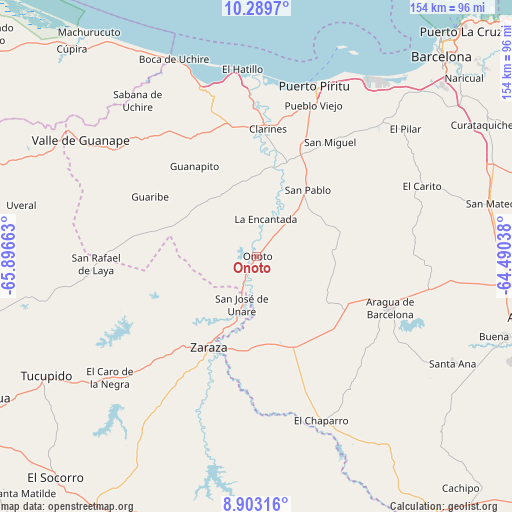
Onoto GPS coordinates[2]
9° 35' 49.704" North, 65° 11' 36.6" West
| Map corner | latitude | longitude |
|---|---|---|
| Upper-left | 10.2897°, | -65.89663° |
| Center: | 9.59714°, | -65.1935° |
| Lower-right: | 8.90316°, | -64.49038° |
| Map W x H: | 154.2×154.2 km | = 95.8×95.8mi |
| max Lat: | 11.94788° ⇑50.4% North |
| Onoto: | 9.59714° |
| min Lat: | ⇓49.6% South 1.92027° |
| min Long | Onoto | max Long |
| -72.55212° | -65.1935° | -60.99778° |
| W 81.7%⇐ | ⇒18.3% E |
Elevation
Elevation of Onoto is 28 m = 92 ft, and this is 352.6 m = 1157 ft below average elevation for this country.
| Max E: |
2986 m = 9797 ft | 86% |
| Avg. | 380.6 m = 1249 ft | |
| Onoto | 28 m = 92 ft | |
Min E: |
-4 m = -13 ft | 14% |
See also: Venezuela elevation on elevation.city.
Geographical zone
Onoto is located in North Torrid zone (between Equator and Tropic of Cancer). Distance of Equator is 1067.1 km =663.1 mi to South.| Distance of | km | miles | from Onoto |
|---|---|---|---|
| North Pole | 8940 | 5555.1 | to North |
| Arctic Circle | 6334.1 | 3935.8 | to North |
| Tropic Cancer | 1538.8 | 956.2 | to North |
| Equator | 1067.1 | 663.1 | to South |


Nearby cities:
15 places around Onoto: (largest is in red/bold)
• Anaco
82.1 km =51 mi,  103°
103°
• Aragua de Barcelona
42.9 km =26.7 mi,  111°
111°
• Barcelona
81.7 km =50.8 mi,  42°
42°
• Boca de Uchire
64.5 km =40.1 mi,  337°
337°
• Clarines
38.2 km =23.7 mi,  4°
4°
• Cúpira
83.8 km =52.1 mi,  318°
318°
• El Chaparro
53.1 km =33 mi,  158°
158°
• Puerto Píritu
54.1 km =33.6 mi,  18°
18°
• Píritu
52.3 km =32.5 mi, 19°
• San José de Guaribe
73.9 km =45.9 mi,  293°
293°
• San Mateo
72.4 km =45 mi,  77°
77°
• Santa Ana
67.4 km =41.9 mi,  118°
118°
• Tucupido
72.9 km =45.3 mi,  240°
240°
• Valle de Guanape
63.1 km =39.2 mi,  303°
303°
• Zaraza
31 km =19.3 mi,  207°
207°
Sources, notices
• [Note1] Compared only with cities in Venezuela existing in our database
• [Src1] Map data: © OpenStreetMap contributors (CC-BY-SA)
• [Src2] Other city data from geonames.org with taken over terms of usage.
• [Src3] Geographical zone / Annual Mean Temperature by Robert A. Rohde @ Wikipedia
