El Chaparro geodata
El Chaparro (Anzoátegui) is a seat of a second-order administrative division; located in Venezuela in America/Caracas (GMT-4) time zone. In our database, there are 108 cities with bigger population. Compared to other cities in Venezuela, 60.6% of cities are located further ↑North; 83% of cities are located further ←West and 66.9% of cities have higher elevation than El Chaparro. Note1


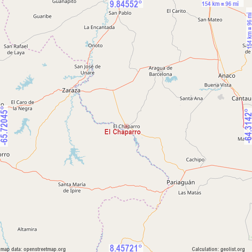
El Chaparro GPS coordinates[2]
9° 9' 7.344" North, 65° 1' 2.352" West
| Map corner | latitude | longitude |
|---|---|---|
| Upper-left | 9.84552°, | -65.72045° |
| Center: | 9.15204°, | -65.01732° |
| Lower-right: | 8.45721°, | -64.3142° |
| Map W x H: | 154.4×154.4 km | = 95.9×95.9mi |
| max Lat: | 11.94788° ⇑60.6% North |
| El Chaparro: | 9.15204° |
| min Lat: | ⇓39.4% South 1.92027° |
| min Long | El Chaparro | max Long |
| -72.55212° | -65.01732° | -60.99778° |
| W 83%⇐ | ⇒17% E |
Elevation
Elevation of El Chaparro is 94 m = 308 ft, and this is 286.6 m = 940 ft below average elevation for this country.
| Max E: |
2986 m = 9797 ft | 66.9% |
| Avg. | 380.6 m = 1249 ft | |
| El Chaparro | 94 m = 308 ft | |
Min E: |
-4 m = -13 ft | 33.1% |
See also: Venezuela elevation on elevation.city.
Geographical zone
El Chaparro is located in North Torrid zone (between Equator and Tropic of Cancer). Distance of Equator is 1017.6 km =632.3 mi to South.| Distance of | km | miles | from El Chaparro |
|---|---|---|---|
| North Pole | 8989.5 | 5585.8 | to North |
| Arctic Circle | 6383.6 | 3966.6 | to North |
| Tropic Cancer | 1588.3 | 986.9 | to North |
| Equator | 1017.6 | 632.3 | to South |


Nearby cities:
15 places around El Chaparro: (largest is in red/bold)
• Anaco
68.1 km =42.3 mi,  63°
63°
• Aragua de Barcelona
39.6 km =24.6 mi,  31°
31°
• Cantaura
74.3 km =46.2 mi,  76°
76°
• Clarines
89.1 km =55.4 mi,  349°
349°
• El Socorro
81.5 km =50.6 mi,  257°
257°
• El Tigre
88.9 km =55.2 mi,  109°
109°
• Onoto
53.1 km =33 mi,  338°
338°
• Pariaguán
48.1 km =29.9 mi,  135°
135°
• Píritu
98.7 km =61.3 mi,  359°
359°
• San José de Guanipa
98.1 km =61 mi, 107°
• San Mateo
83.1 km =51.6 mi,  38°
38°
• Santa Ana
43.3 km =26.9 mi,  66°
66°
• Santa María de Ipire
50.2 km =31.2 mi,  221°
221°
• Tucupido
83.9 km =52.1 mi,  279°
279°
• Zaraza
40.3 km =25 mi,  303°
303°
Sources, notices
• [Note1] Compared only with cities in Venezuela existing in our database
• [Src1] Map data: © OpenStreetMap contributors (CC-BY-SA)
• [Src2] Other city data from geonames.org with taken over terms of usage.
• [Src3] Geographical zone / Annual Mean Temperature by Robert A. Rohde @ Wikipedia
