Chaguaramas geodata
Chaguaramas (Guárico) is a seat of a second-order administrative division; located in Venezuela in America/Caracas (GMT-4) time zone. In our database, there are 108 cities with bigger population. Compared to other cities in Venezuela, 56.5% of cities are located further ↑North; 77.4% of cities are located further ←West and 55.2% of cities have higher elevation than Chaguaramas. Note1


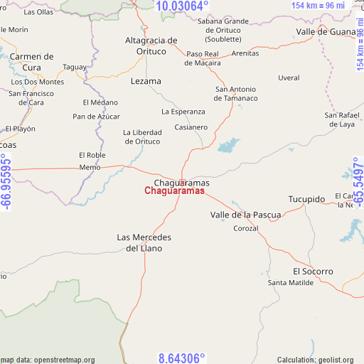
Chaguaramas GPS coordinates[2]
9° 20' 15.144" North, 66° 15' 10.152" West
| Map corner | latitude | longitude |
|---|---|---|
| Upper-left | 10.03064°, | -66.95595° |
| Center: | 9.33754°, | -66.25282° |
| Lower-right: | 8.64306°, | -65.5497° |
| Map W x H: | 154.3×154.3 km | = 95.9×95.9mi |
| max Lat: | 11.94788° ⇑56.5% North |
| Chaguaramas: | 9.33754° |
| min Lat: | ⇓43.5% South 1.92027° |
| min Long | Chaguaramas | max Long |
| -72.55212° | -66.25282° | -60.99778° |
| W 77.4%⇐ | ⇒22.6% E |
Elevation
Elevation of Chaguaramas is 159 m = 522 ft, and this is 221.6 m = 727 ft below average elevation for this country.
| Max E: |
2986 m = 9797 ft | 55.2% |
| Avg. | 380.6 m = 1249 ft | |
| Chaguaramas | 159 m = 522 ft | |
Min E: |
-4 m = -13 ft | 44.8% |
See also: Venezuela elevation on elevation.city.
Geographical zone
Chaguaramas is located in North Torrid zone (between Equator and Tropic of Cancer). Distance of Equator is 1038.2 km =645.1 mi to South.| Distance of | km | miles | from Chaguaramas |
|---|---|---|---|
| North Pole | 8968.8 | 5573 | to North |
| Arctic Circle | 6362.9 | 3953.7 | to North |
| Tropic Cancer | 1567.7 | 974.1 | to North |
| Equator | 1038.2 | 645.1 | to South |


Nearby cities:
15 places around Chaguaramas: (largest is in red/bold)
• Altagracia de Orituco
59.8 km =37.2 mi,  346°
346°
• Barbacoas
80.7 km =50.1 mi,  281°
281°
• Camatagua
87.4 km =54.3 mi,  304°
304°
• Caucagua
106 km =65.9 mi, 352°
• El Socorro
67.8 km =42.1 mi,  124°
124°
• El Sombrero
88.5 km =55 mi,  273°
273°
• Las Mercedes
29.8 km =18.5 mi,  211°
211°
• Ocumare del Tuy
104 km =64.6 mi,  326°
326°
• Palmasola
52.2 km =32.4 mi,  257°
257°
• San Francisco de Yare
108 km =67.1 mi, 329°
• San José de Guaribe
75.5 km =46.9 mi,  39°
39°
• Tucupido
53.3 km =33.1 mi,  97°
97°
• Valle de Guanape
89.9 km =55.9 mi, 44°
• Valle de La Pascua
30.2 km =18.8 mi, 116°
• Zaraza
101.9 km =63.3 mi,  89°
89°
Sources, notices
• [Note1] Compared only with cities in Venezuela existing in our database
• [Src1] Map data: © OpenStreetMap contributors (CC-BY-SA)
• [Src2] Other city data from geonames.org with taken over terms of usage.
• [Src3] Geographical zone / Annual Mean Temperature by Robert A. Rohde @ Wikipedia
