El Sombrero geodata
El Sombrero (Guárico) is a seat of a second-order administrative division; located in Venezuela in America/Caracas (GMT-4) time zone. In our database, there are 108 cities with bigger population. Compared to other cities in Venezuela, 54.7% of cities are located further ↑North; 67.9% of cities are located further ←West and 54.2% of cities have higher elevation than El Sombrero. Note1


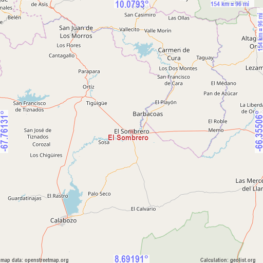
El Sombrero GPS coordinates[2]
9° 23' 10.68" North, 67° 3' 29.448" West
| Map corner | latitude | longitude |
|---|---|---|
| Upper-left | 10.0793°, | -67.76131° |
| Center: | 9.3863°, | -67.05818° |
| Lower-right: | 8.69191°, | -66.35506° |
| Map W x H: | 154.3×154.3 km | = 95.9×95.9mi |
| max Lat: | 11.94788° ⇑54.7% North |
| El Sombrero: | 9.3863° |
| min Lat: | ⇓45.3% South 1.92027° |
| min Long | El Sombrero | max Long |
| -72.55212° | -67.05818° | -60.99778° |
| W 67.9%⇐ | ⇒32.1% E |
Elevation
Elevation of El Sombrero is 163 m = 535 ft, and this is 217.6 m = 714 ft below average elevation for this country.
| Max E: |
2986 m = 9797 ft | 54.2% |
| Avg. | 380.6 m = 1249 ft | |
| El Sombrero | 163 m = 535 ft | |
Min E: |
-4 m = -13 ft | 45.8% |
See also: Venezuela elevation on elevation.city.
Geographical zone
El Sombrero is located in North Torrid zone (between Equator and Tropic of Cancer). Distance of Equator is 1043.7 km =648.5 mi to South.| Distance of | km | miles | from El Sombrero |
|---|---|---|---|
| North Pole | 8963.4 | 5569.6 | to North |
| Arctic Circle | 6357.5 | 3950.4 | to North |
| Tropic Cancer | 1562.3 | 970.8 | to North |
| Equator | 1043.7 | 648.5 | to South |


Nearby cities:
15 places around El Sombrero: (largest is in red/bold)
• Altagracia de Orituco
91 km =56.5 mi,  54°
54°
• Barbacoas
13.8 km =8.6 mi,  41°
41°
• Calabozo
65.6 km =40.8 mi,  218°
218°
• Camatagua
47.6 km =29.6 mi,  20°
20°
• Chaguaramas
88.5 km =55 mi,  93°
93°
• Cúa
88.4 km =54.9 mi,  12°
12°
• Las Mercedes
78.9 km =49 mi,  112°
112°
• Ocumare del Tuy
87.1 km =54.1 mi, 20°
• Ortiz
36.5 km =22.7 mi,  315°
315°
• Palmasola
41.2 km =25.6 mi, 114°
• San Casimiro
68.6 km =42.6 mi,  3°
3°
• San Francisco de Yare
94.4 km =58.7 mi, 21°
• San Juan de los Morros
66.8 km =41.5 mi,  330°
330°
• San Sebastián
62.9 km =39.1 mi,  348°
348°
• Villa de Cura
86.6 km =53.8 mi, 326°
Sources, notices
• [Note1] Compared only with cities in Venezuela existing in our database
• [Src1] Map data: © OpenStreetMap contributors (CC-BY-SA)
• [Src2] Other city data from geonames.org with taken over terms of usage.
• [Src3] Geographical zone / Annual Mean Temperature by Robert A. Rohde @ Wikipedia
