Palmasola geodata
Palmasola (Guárico) is a seat of a second-order administrative division; located in Venezuela in America/Caracas (GMT-4) time zone. In our database, there are 108 cities with bigger population. Compared to other cities in Venezuela, 59.5% of cities are located further ↑North; 75.1% of cities are located further ←West and 59% of cities have higher elevation than Palmasola. Note1


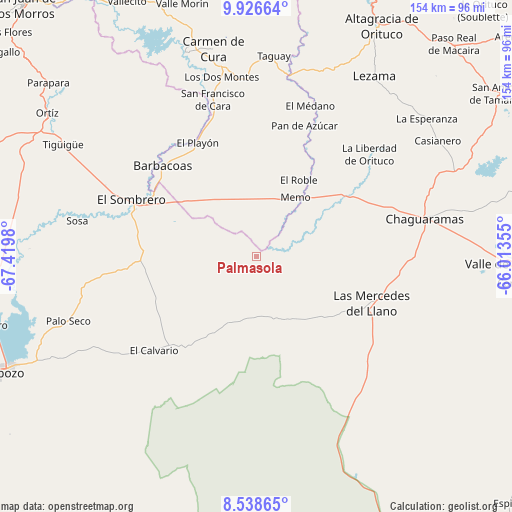
Palmasola GPS coordinates[2]
9° 13' 59.988" North, 66° 43' 0.012" West
| Map corner | latitude | longitude |
|---|---|---|
| Upper-left | 9.92664°, | -67.4198° |
| Center: | 9.23333°, | -66.71667° |
| Lower-right: | 8.53865°, | -66.01355° |
| Map W x H: | 154.3×154.3 km | = 95.9×95.9mi |
| max Lat: | 11.94788° ⇑59.5% North |
| Palmasola: | 9.23333° |
| min Lat: | ⇓40.5% South 1.92027° |
| min Long | Palmasola | max Long |
| -72.55212° | -66.71667° | -60.99778° |
| W 75.1%⇐ | ⇒24.9% E |
Elevation
Elevation of Palmasola is 142 m = 466 ft, and this is 238.6 m = 783 ft below average elevation for this country.
| Max E: |
2986 m = 9797 ft | 59% |
| Avg. | 380.6 m = 1249 ft | |
| Palmasola | 142 m = 466 ft | |
Min E: |
-4 m = -13 ft | 41% |
See also: Venezuela elevation on elevation.city.
Geographical zone
Palmasola is located in North Torrid zone (between Equator and Tropic of Cancer). Distance of Equator is 1026.7 km =638 mi to South.| Distance of | km | miles | from Palmasola |
|---|---|---|---|
| North Pole | 8980.4 | 5580.2 | to North |
| Arctic Circle | 6374.5 | 3960.9 | to North |
| Tropic Cancer | 1579.3 | 981.3 | to North |
| Equator | 1026.7 | 638 | to South |


Nearby cities:
15 places around Palmasola: (largest is in red/bold)
• Altagracia de Orituco
78.8 km =49 mi,  27°
27°
• Barbacoas
39.3 km =24.4 mi,  313°
313°
• Calabozo
85.5 km =53.1 mi,  246°
246°
• Camatagua
65 km =40.4 mi,  341°
341°
• Chaguaramas
52.2 km =32.4 mi,  77°
77°
• Cúa
104.9 km =65.2 mi,  350°
350°
• El Sombrero
41.2 km =25.6 mi,  294°
294°
• Las Mercedes
37.8 km =23.5 mi,  111°
111°
• Ocumare del Tuy
98.6 km =61.3 mi,  356°
356°
• Ortiz
76.3 km =47.4 mi,  304°
304°
• San Casimiro
91.5 km =56.9 mi, 339°
• San Juan de los Morros
102.8 km =63.9 mi,  317°
317°
• San Sebastián
93.2 km =57.9 mi,  327°
327°
• Tucupido
103.8 km =64.5 mi,  87°
87°
• Valle de La Pascua
77.9 km =48.4 mi, 91°
Sources, notices
• [Note1] Compared only with cities in Venezuela existing in our database
• [Src1] Map data: © OpenStreetMap contributors (CC-BY-SA)
• [Src2] Other city data from geonames.org with taken over terms of usage.
• [Src3] Geographical zone / Annual Mean Temperature by Robert A. Rohde @ Wikipedia
