Carúpano geodata
Carúpano (Sucre) is a seat of a second-order administrative division; located in Venezuela in America/Caracas (GMT-4) time zone. With population of 112,082 people, there are 39 cities with bigger population in this country. Compared to other cities in Venezuela, 89.3% of cities are located further ↓South; 93.9% of cities are located further ←West and 89.6% of cities have higher elevation than Carúpano. Note1


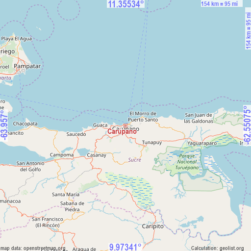
Carúpano GPS coordinates[2]
10° 39' 54.576" North, 63° 15' 13.932" West
| Map corner | latitude | longitude |
|---|---|---|
| Upper-left | 11.35534°, | -63.957° |
| Center: | 10.66516°, | -63.25387° |
| Lower-right: | 9.97341°, | -62.55075° |
| Map W x H: | 153.7×153.7 km | = 95.5×95.5mi |
| max Lat: | 11.94788° ⇑10.7% North |
| Carúpano: | 10.66516° |
| min Lat: | ⇓89.3% South 1.92027° |
| min Long | Carúpano | max Long |
| -72.55212° | -63.25387° | -60.99778° |
| W 93.9%⇐ | ⇒6.1% E |
Elevation
Elevation of Carúpano is 15 m = 49 ft, and this is 365.6 m = 1199 ft below average elevation for this country.
| Max E: |
2986 m = 9797 ft | 89.6% |
| Avg. | 380.6 m = 1249 ft | |
| Carúpano | 15 m = 49 ft | |
Min E: |
-4 m = -13 ft | 10.4% |
See also: Carúpano elevation on elevation.city.
Geographical zone
Carúpano is located in North Torrid zone (between Equator and Tropic of Cancer). Distance of Equator is 1185.9 km =736.9 mi to South.| Distance of | km | miles | from Carúpano |
|---|---|---|---|
| North Pole | 8821.2 | 5481.2 | to North |
| Arctic Circle | 6215.3 | 3862 | to North |
| Tropic Cancer | 1420.1 | 882.4 | to North |
| Equator | 1185.9 | 736.9 | to South |


Nearby cities:
15 places around Carúpano: (largest is in red/bold)
• Cariaco
37.7 km =23.4 mi,  240°
240°
• Caripe
61 km =37.9 mi,  206°
206°
• Caripito
63.8 km =39.6 mi,  164°
164°
• Casanay
25.3 km =15.7 mi,  224°
224°
• El Pilar
17 km =10.6 mi,  140°
140°
• Irapa
74.2 km =46.1 mi,  98°
98°
• Marigüitar
74.8 km =46.5 mi,  251°
251°
• Pampatar
69.7 km =43.3 mi,  302°
302°
• Porlamar
74.7 km =46.4 mi, 295°
• Quiriquire
76.3 km =47.4 mi,  177°
177°
• Río Caribe
16.3 km =10.1 mi,  77°
77°
• San Antonio del Golfo
63.5 km =39.5 mi, 247°
• San José de Aerocuar
10.9 km =6.8 mi,  228°
228°
• Tunapuy
18.9 km =11.7 mi,  122°
122°
• Yaguaraparo
48 km =29.8 mi, 102°
Sources, notices
• [Note1] Compared only with cities in Venezuela existing in our database
• [Src1] Map data: © OpenStreetMap contributors (CC-BY-SA)
• [Src2] Other city data from geonames.org with taken over terms of usage.
• [Src3] Geographical zone / Annual Mean Temperature by Robert A. Rohde @ Wikipedia
