Mucuchíes geodata
Mucuchíes (Mérida) is a seat of a second-order administrative division; located in Venezuela in America/Caracas (GMT-4) time zone. In our database, there are 108 cities with bigger population. Compared to other cities in Venezuela, 69% of cities are located further ↑North; 78.9% of cities are located further →East and 100% of cities have lower elevation than Mucuchíes. Note1


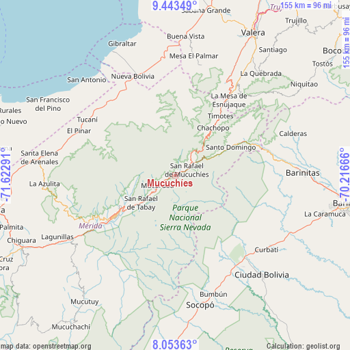
Mucuchíes GPS coordinates[2]
8° 44' 57.156" North, 70° 55' 11.208" West
| Map corner | latitude | longitude |
|---|---|---|
| Upper-left | 9.44349°, | -71.62291° |
| Center: | 8.74921°, | -70.91978° |
| Lower-right: | 8.05363°, | -70.21666° |
| Map W x H: | 154.5×154.5 km | = 96×96mi |
| max Lat: | 11.94788° ⇑69% North |
| Mucuchíes: | 8.74921° |
| min Lat: | ⇓31% South 1.92027° |
| min Long | Mucuchíes | max Long |
| -72.55212° | -70.91978° | -60.99778° |
| W 21.1%⇐ | ⇒78.9% E |
Elevation
Elevation of Mucuchíes is 2986 m = 9797 ft, and this is 2605.4 m = 8548 ft above average elevation for this country.
| Max E: |
2986 m = 9797 ft | 0% |
| Mucuchíes | 2986 m 9797 ft | |
| Avg. | 380.6 m = 1249 ft | |
Min E: |
-4 m = -13 ft | 100% |
See also: Venezuela elevation on elevation.city.
Geographical zone
Mucuchíes is located in North Torrid zone (between Equator and Tropic of Cancer). Distance of Equator is 972.8 km =604.5 mi to South.| Distance of | km | miles | from Mucuchíes |
|---|---|---|---|
| North Pole | 9034.2 | 5613.6 | to North |
| Arctic Circle | 6428.4 | 3994.4 | to North |
| Tropic Cancer | 1633.1 | 1014.8 | to North |
| Equator | 972.8 | 604.5 | to South |


Nearby cities:
15 places around Mucuchíes: (largest is in red/bold)
• Altamira
46.6 km =29 mi,  79°
79°
• Bum Bum
55.2 km =34.3 mi,  162°
162°
• Calderas
55 km =34.2 mi,  70°
70°
• Curbatí
51.8 km =32.2 mi,  129°
129°
• Ejido
41.9 km =26 mi,  237°
237°
• Monte Carmelo
50.2 km =31.2 mi,  13°
13°
• Mucumpiz
43.8 km =27.2 mi,  212°
212°
• Mérida
31.5 km =19.6 mi, 235°
• Nueva Bolivia
47.4 km =29.5 mi,  336°
336°
• Pueblo Llano
34.1 km =21.2 mi,  57°
57°
• Santo Domingo
27.6 km =17.1 mi, 63°
• Tabay
21.8 km =13.5 mi,  233°
233°
• Timotes
32.6 km =20.3 mi,  37°
37°
• Torondoy
33.4 km =20.8 mi, 341°
• Tucaní
45.9 km =28.5 mi,  302°
302°
Sources, notices
• [Note1] Compared only with cities in Venezuela existing in our database
• [Src1] Map data: © OpenStreetMap contributors (CC-BY-SA)
• [Src2] Other city data from geonames.org with taken over terms of usage.
• [Src3] Geographical zone / Annual Mean Temperature by Robert A. Rohde @ Wikipedia
