Soledad geodata
Soledad (Anzoátegui) is a seat of a second-order administrative division; located in Venezuela in America/Caracas (GMT-4) time zone. In our database, there are 108 cities with bigger population. Compared to other cities in Venezuela, 82.2% of cities are located further ↑North; 91.9% of cities are located further ←West and 84.2% of cities have higher elevation than Soledad. Note1


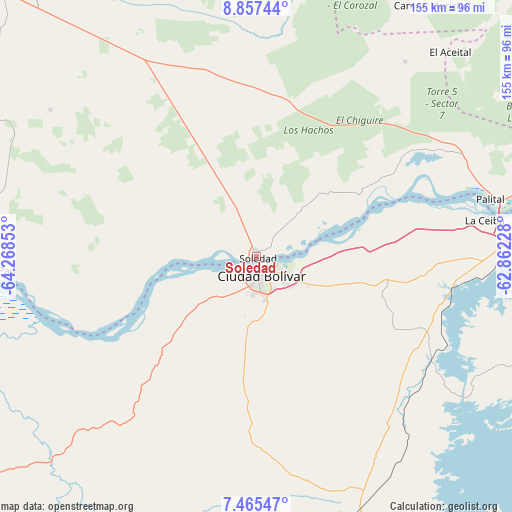
Soledad GPS coordinates[2]
8° 9' 43.416" North, 63° 33' 55.44" West
| Map corner | latitude | longitude |
|---|---|---|
| Upper-left | 8.85744°, | -64.26853° |
| Center: | 8.16206°, | -63.5654° |
| Lower-right: | 7.46547°, | -62.86228° |
| Map W x H: | 154.8×154.8 km | = 96.2×96.2mi |
| max Lat: | 11.94788° ⇑82.2% North |
| Soledad: | 8.16206° |
| min Lat: | ⇓17.8% South 1.92027° |
| min Long | Soledad | max Long |
| -72.55212° | -63.5654° | -60.99778° |
| W 91.9%⇐ | ⇒8.1% E |
Elevation
Elevation of Soledad is 34 m = 112 ft, and this is 346.6 m = 1137 ft below average elevation for this country.
| Max E: |
2986 m = 9797 ft | 84.2% |
| Avg. | 380.6 m = 1249 ft | |
| Soledad | 34 m = 112 ft | |
Min E: |
-4 m = -13 ft | 15.8% |
See also: Venezuela elevation on elevation.city.
Geographical zone
Soledad is located in North Torrid zone (between Equator and Tropic of Cancer). Distance of Equator is 907.5 km =563.9 mi to South.| Distance of | km | miles | from Soledad |
|---|---|---|---|
| North Pole | 9099.5 | 5654.2 | to North |
| Arctic Circle | 6493.6 | 4034.9 | to North |
| Tropic Cancer | 1698.4 | 1055.3 | to North |
| Equator | 907.5 | 563.9 | to South |


Nearby cities:
15 places around Soledad: (largest is in red/bold)
• Aguasay
141.6 km =88 mi,  352°
352°
• Barrancas
162 km =100.7 mi,  68°
68°
• Cantaura
154.2 km =95.8 mi,  325°
325°
• Ciudad Bolívar
4.5 km =2.8 mi,  143°
143°
• Ciudad Guayana
103.9 km =64.6 mi,  78°
78°
• Ciudad Piar
83.4 km =51.8 mi,  161°
161°
• El Tigre
110.7 km =68.8 mi,  316°
316°
• Mapire
134.5 km =83.6 mi,  249°
249°
• Pariaguán
147 km =91.3 mi,  301°
301°
• San José de Guanipa
104.2 km =64.7 mi, 320°
• Santa Bárbara
160.8 km =99.9 mi,  358°
358°
• Sierra Imataca
124.9 km =77.6 mi, 78°
• Temblador
138 km =85.7 mi,  47°
47°
• Upata
128.7 km =80 mi,  97°
97°
• Uracoa
162.4 km =100.9 mi,  55°
55°
Sources, notices
• [Note1] Compared only with cities in Venezuela existing in our database
• [Src1] Map data: © OpenStreetMap contributors (CC-BY-SA)
• [Src2] Other city data from geonames.org with taken over terms of usage.
• [Src3] Geographical zone / Annual Mean Temperature by Robert A. Rohde @ Wikipedia
