Ciudad Guayana geodata
Ciudad Guayana (Bolívar) is a seat of a second-order administrative division; located in Venezuela in America/Caracas (GMT-4) time zone. With population of 746,535 people, there are 5 cities with bigger population in this country. Compared to other cities in Venezuela, 77.9% of cities are located further ↑North; 96.2% of cities are located further ←West and 65.1% of cities have higher elevation than Ciudad Guayana. Note1


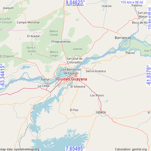
Ciudad Guayana GPS coordinates[2]
8° 21' 4.392" North, 62° 38' 27.672" West
| Map corner | latitude | longitude |
|---|---|---|
| Upper-left | 9.04625°, | -63.34415° |
| Center: | 8.35122°, | -62.64102° |
| Lower-right: | 7.65495°, | -61.9379° |
| Map W x H: | 154.7×154.7 km | = 96.1×96.1mi |
| max Lat: | 11.94788° ⇑77.9% North |
| Ciudad Guayana: | 8.35122° |
| min Lat: | ⇓22.1% South 1.92027° |
| min Long | Ciudad Guayana | max Long |
| -72.55212° | -62.64102° | -60.99778° |
| W 96.2%⇐ | ⇒3.8% E |
Elevation
Elevation of Ciudad Guayana is 103 m = 338 ft, and this is 277.6 m = 911 ft below average elevation for this country.
| Max E: |
2986 m = 9797 ft | 65.1% |
| Avg. | 380.6 m = 1249 ft | |
| Ciudad Guayana | 103 m = 338 ft | |
Min E: |
-4 m = -13 ft | 34.9% |
See also: Ciudad Guayana elevation on elevation.city.
Geographical zone
Ciudad Guayana is located in North Torrid zone (between Equator and Tropic of Cancer). Distance of Equator is 928.6 km =577 mi to South.| Distance of | km | miles | from Ciudad Guayana |
|---|---|---|---|
| North Pole | 9078.5 | 5641.1 | to North |
| Arctic Circle | 6472.6 | 4021.9 | to North |
| Tropic Cancer | 1677.4 | 1042.3 | to North |
| Equator | 928.6 | 577 | to South |


Nearby cities:
15 places around Ciudad Guayana: (largest is in red/bold)
• Aguasay
169.1 km =105.1 mi,  314°
314°
• Barrancas
62.3 km =38.7 mi,  51°
51°
• Ciudad Bolívar
102 km =63.4 mi,  256°
256°
• Ciudad Piar
124.8 km =77.5 mi,  216°
216°
• El Callao
143.2 km =89 mi,  141°
141°
• El Palmar
89.2 km =55.4 mi,  115°
115°
• El Palmer
90.6 km =56.3 mi,  112°
112°
• Guasipati
127.2 km =79 mi, 139°
• Maturín
166.1 km =103.2 mi,  338°
338°
• Sierra Imataca
21.1 km =13.1 mi,  77°
77°
• Soledad
103.9 km =64.6 mi, 258°
• Temblador
72.7 km =45.2 mi,  359°
359°
• Tucupita
102 km =63.4 mi,  39°
39°
• Upata
45.4 km =28.2 mi,  145°
145°
• Uracoa
78.2 km =48.6 mi,  23°
23°
Sources, notices
• [Note1] Compared only with cities in Venezuela existing in our database
• [Src1] Map data: © OpenStreetMap contributors (CC-BY-SA)
• [Src2] Other city data from geonames.org with taken over terms of usage.
• [Src3] Geographical zone / Annual Mean Temperature by Robert A. Rohde @ Wikipedia
