El Tigre geodata
El Tigre (Anzoátegui) is a seat of a second-order administrative division; located in Venezuela in America/Caracas (GMT-4) time zone. With population of 150,999 people, there are 28 cities with bigger population in this country. Compared to other cities in Venezuela, 65.9% of cities are located further ↑North; 86.3% of cities are located further ←West and 61.6% of cities have lower elevation than El Tigre. Note1


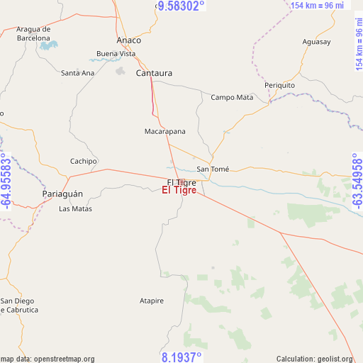
El Tigre GPS coordinates[2]
8° 53' 20.472" North, 64° 15' 9.72" West
| Map corner | latitude | longitude |
|---|---|---|
| Upper-left | 9.58302°, | -64.95583° |
| Center: | 8.88902°, | -64.2527° |
| Lower-right: | 8.1937°, | -63.54958° |
| Map W x H: | 154.5×154.5 km | = 96×96mi |
| max Lat: | 11.94788° ⇑65.9% North |
| El Tigre: | 8.88902° |
| min Lat: | ⇓34.1% South 1.92027° |
| min Long | El Tigre | max Long |
| -72.55212° | -64.2527° | -60.99778° |
| W 86.3%⇐ | ⇒13.7% E |
Elevation
Elevation of El Tigre is 276 m = 906 ft, and this is 104.6 m = 343 ft below average elevation for this country.
| Max E: |
2986 m = 9797 ft | 38.4% |
| Avg. | 380.6 m = 1249 ft | |
| El Tigre | 276 m = 906 ft | |
Min E: |
-4 m = -13 ft | 61.6% |
See also: El Tigre elevation on elevation.city.
Geographical zone
El Tigre is located in North Torrid zone (between Equator and Tropic of Cancer). Distance of Equator is 988.4 km =614.2 mi to South.| Distance of | km | miles | from El Tigre |
|---|---|---|---|
| North Pole | 9018.7 | 5604 | to North |
| Arctic Circle | 6412.8 | 3984.7 | to North |
| Tropic Cancer | 1617.6 | 1005.1 | to North |
| Equator | 988.4 | 614.2 | to South |


Nearby cities:
15 places around El Tigre: (largest is in red/bold)
• Aguasay
82.7 km =51.4 mi,  43°
43°
• Anaco
64.4 km =40 mi,  338°
338°
• Aragua de Barcelona
89.3 km =55.5 mi,  314°
314°
• Caicara
124.8 km =77.5 mi,  34°
34°
• Cantaura
47.8 km =29.7 mi,  345°
345°
• Ciudad Bolívar
115.2 km =71.6 mi,  137°
137°
• El Chaparro
88.9 km =55.2 mi,  289°
289°
• Pariaguán
50.6 km =31.4 mi,  264°
264°
• Punta de Mata
113.8 km =70.7 mi, 38°
• San José de Guanipa
9.6 km =6 mi,  91°
91°
• San Mateo
100.1 km =62.2 mi, 341°
• Santa Ana
64 km =39.8 mi,  316°
316°
• Santa Bárbara
106.6 km =66.2 mi, 41°
• Santa María de Ipire
117.8 km =73.2 mi,  266°
266°
• Soledad
110.7 km =68.8 mi, 136°
Sources, notices
• [Note1] Compared only with cities in Venezuela existing in our database
• [Src1] Map data: © OpenStreetMap contributors (CC-BY-SA)
• [Src2] Other city data from geonames.org with taken over terms of usage.
• [Src3] Geographical zone / Annual Mean Temperature by Robert A. Rohde @ Wikipedia
