Cantaura geodata
Cantaura (Anzoátegui) is a seat of a second-order administrative division; located in Venezuela in America/Caracas (GMT-4) time zone. With population of 33,040 people, there are 95 cities with bigger population in this country. Compared to other cities in Venezuela, 57.5% of cities are located further ↑North; 85.8% of cities are located further ←West and 60.8% of cities have lower elevation than Cantaura. Note1


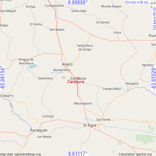
Cantaura GPS coordinates[2]
9° 18' 20.556" North, 64° 21' 30.276" West
| Map corner | latitude | longitude |
|---|---|---|
| Upper-left | 9.99888°, | -65.06154° |
| Center: | 9.30571°, | -64.35841° |
| Lower-right: | 8.61117°, | -63.65529° |
| Map W x H: | 154.3×154.3 km | = 95.9×95.9mi |
| max Lat: | 11.94788° ⇑57.5% North |
| Cantaura: | 9.30571° |
| min Lat: | ⇓42.5% South 1.92027° |
| min Long | Cantaura | max Long |
| -72.55212° | -64.35841° | -60.99778° |
| W 85.8%⇐ | ⇒14.2% E |
Elevation
Elevation of Cantaura is 263 m = 863 ft, and this is 117.6 m = 386 ft below average elevation for this country.
| Max E: |
2986 m = 9797 ft | 39.2% |
| Avg. | 380.6 m = 1249 ft | |
| Cantaura | 263 m = 863 ft | |
Min E: |
-4 m = -13 ft | 60.8% |
See also: Venezuela elevation on elevation.city.
Geographical zone
Cantaura is located in North Torrid zone (between Equator and Tropic of Cancer). Distance of Equator is 1034.7 km =642.9 mi to South.| Distance of | km | miles | from Cantaura |
|---|---|---|---|
| North Pole | 8972.4 | 5575.2 | to North |
| Arctic Circle | 6366.5 | 3956 | to North |
| Tropic Cancer | 1571.2 | 976.3 | to North |
| Equator | 1034.7 | 642.9 | to South |


Nearby cities:
15 places around Cantaura: (largest is in red/bold)
• Aguasay
70.1 km =43.6 mi,  79°
79°
• Anaco
18 km =11.2 mi,  319°
319°
• Aragua de Barcelona
54.3 km =33.7 mi,  287°
287°
• Barcelona
99.1 km =61.6 mi,  338°
338°
• Caicara
99.6 km =61.9 mi,  55°
55°
• El Chaparro
74.3 km =46.2 mi,  256°
256°
• El Tigre
47.8 km =29.7 mi,  165°
165°
• Lecherías
105.1 km =65.3 mi, 339°
• Onoto
97.2 km =60.4 mi, 289°
• Pariaguán
64.3 km =40 mi,  216°
216°
• Punta de Mata
92.7 km =57.6 mi, 62°
• San José de Guanipa
51.1 km =31.8 mi,  155°
155°
• San Mateo
52.6 km =32.7 mi, 336°
• Santa Ana
32.5 km =20.2 mi,  269°
269°
• Santa Bárbara
88.7 km =55.1 mi,  67°
67°
Sources, notices
• [Note1] Compared only with cities in Venezuela existing in our database
• [Src1] Map data: © OpenStreetMap contributors (CC-BY-SA)
• [Src2] Other city data from geonames.org with taken over terms of usage.
• [Src3] Geographical zone / Annual Mean Temperature by Robert A. Rohde @ Wikipedia
