San José de Guanipa geodata
San José de Guanipa (Anzoátegui) is a seat of a second-order administrative division; located in Venezuela in America/Caracas (GMT-4) time zone. With population of 62,128 people, there are 62 cities with bigger population in this country. Compared to other cities in Venezuela, 66.2% of cities are located further ↑North; 87% of cities are located further ←West and 60.6% of cities have lower elevation than San José de Guanipa. Note1


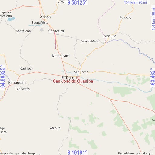
San José de Guanipa GPS coordinates[2]
8° 53' 14.064" North, 64° 9' 54.432" West
| Map corner | latitude | longitude |
|---|---|---|
| Upper-left | 9.58125°, | -64.86825° |
| Center: | 8.88724°, | -64.16512° |
| Lower-right: | 8.19191°, | -63.462° |
| Map W x H: | 154.5×154.5 km | = 96×96mi |
| max Lat: | 11.94788° ⇑66.2% North |
| San José de Guanipa: | 8.88724° |
| min Lat: | ⇓33.8% South 1.92027° |
| min Long | San José de Gu | max Long |
| -72.55212° | -64.16512° | -60.99778° |
| W 87%⇐ | ⇒13% E |
Elevation
Elevation of San José de Guanipa is 261 m = 856 ft, and this is 119.6 m = 392 ft below average elevation for this country.
| Max E: |
2986 m = 9797 ft | 39.4% |
| Avg. | 380.6 m = 1249 ft | |
| San José de Guanipa | 261 m = 856 ft | |
Min E: |
-4 m = -13 ft | 60.6% |
See also: San José de Guanipa elevation on elevation.city.
Geographical zone
San José de Guanipa is located in North Torrid zone (between Equator and Tropic of Cancer). Distance of Equator is 988.2 km =614 mi to South.| Distance of | km | miles | from San José de Guanipa |
|---|---|---|---|
| North Pole | 9018.9 | 5604.1 | to North |
| Arctic Circle | 6413 | 3984.9 | to North |
| Tropic Cancer | 1617.8 | 1005.3 | to North |
| Equator | 988.2 | 614 | to South |


Nearby cities:
15 places around San José de Guanipa: (largest is in red/bold)
• Aguasay
76.5 km =47.5 mi,  38°
38°
• Anaco
68.7 km =42.7 mi,  331°
331°
• Aragua de Barcelona
96.5 km =60 mi,  310°
310°
• Caicara
119.9 km =74.5 mi,  30°
30°
• Cantaura
51.1 km =31.8 mi,  335°
335°
• Ciudad Bolívar
108.7 km =67.5 mi,  140°
140°
• El Chaparro
98.1 km =61 mi,  287°
287°
• El Tigre
9.6 km =6 mi,  271°
271°
• Pariaguán
60.1 km =37.3 mi, 265°
• Punta de Mata
108.2 km =67.2 mi, 34°
• San Mateo
103.8 km =64.5 mi, 336°
• Santa Ana
71.1 km =44.2 mi, 310°
• Santa Bárbara
100.7 km =62.6 mi, 37°
• Santa María de Ipire
127.4 km =79.2 mi, 266°
• Soledad
104.2 km =64.7 mi, 140°
Sources, notices
• [Note1] Compared only with cities in Venezuela existing in our database
• [Src1] Map data: © OpenStreetMap contributors (CC-BY-SA)
• [Src2] Other city data from geonames.org with taken over terms of usage.
• [Src3] Geographical zone / Annual Mean Temperature by Robert A. Rohde @ Wikipedia
