Santa Rosa geodata
Santa Rosa (Barinas) is a seat of a third-order administrative division; located in Venezuela in America/Caracas (GMT-4) time zone. In our database, there are 108 cities with bigger population. Compared to other cities in Venezuela, 75.6% of cities are located further ↑North; 61.3% of cities are located further →East and 63.9% of cities have higher elevation than Santa Rosa. Note1


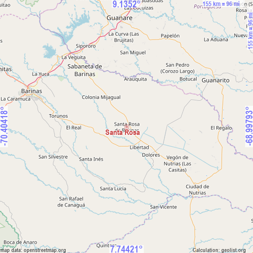
Santa Rosa GPS coordinates[2]
8° 26' 25.188" North, 69° 42' 3.78" West
| Map corner | latitude | longitude |
|---|---|---|
| Upper-left | 9.1352°, | -70.40418° |
| Center: | 8.44033°, | -69.70105° |
| Lower-right: | 7.74421°, | -68.99793° |
| Map W x H: | 154.7×154.7 km | = 96.1×96.1mi |
| max Lat: | 11.94788° ⇑75.6% North |
| Santa Rosa: | 8.44033° |
| min Lat: | ⇓24.4% South 1.92027° |
| min Long | Santa Rosa | max Long |
| -72.55212° | -69.70105° | -60.99778° |
| W 38.7%⇐ | ⇒61.3% E |
Elevation
Elevation of Santa Rosa is 113 m = 371 ft, and this is 267.6 m = 878 ft below average elevation for this country.
| Max E: |
2986 m = 9797 ft | 63.9% |
| Avg. | 380.6 m = 1249 ft | |
| Santa Rosa | 113 m = 371 ft | |
Min E: |
-4 m = -13 ft | 36.1% |
See also: Venezuela elevation on elevation.city.
Geographical zone
Santa Rosa is located in North Torrid zone (between Equator and Tropic of Cancer). Distance of Equator is 938.5 km =583.2 mi to South.| Distance of | km | miles | from Santa Rosa |
|---|---|---|---|
| North Pole | 9068.6 | 5635 | to North |
| Arctic Circle | 6462.7 | 4015.7 | to North |
| Tropic Cancer | 1667.4 | 1036.1 | to North |
| Equator | 938.5 | 583.2 | to South |


Nearby cities:
15 places around Santa Rosa: (largest is in red/bold)
• Arauquita
30.2 km =18.8 mi,  9°
9°
• Boconoito
54.6 km =33.9 mi,  325°
325°
• Dolores
22.7 km =14.1 mi,  139°
139°
• El Real
32.5 km =20.2 mi,  269°
269°
• La Luz
14.4 km =8.9 mi,  249°
249°
• Las Casitas del Vegon de Nutrias
38.5 km =23.9 mi,  126°
126°
• Libertad
14.8 km =9.2 mi,  148°
148°
• Obispos
48.1 km =29.9 mi,  292°
292°
• Sabaneta
43.1 km =26.8 mi,  323°
323°
• San Rafael de Canaguá
57.1 km =35.5 mi,  216°
216°
• San Silvestre
48.6 km =30.2 mi, 247°
• Santa Inés
29.3 km =18.2 mi,  227°
227°
• Santa Lucía
38.6 km =24 mi,  192°
192°
• Torunos
42.3 km =26.3 mi,  279°
279°
• Veguitas
53.6 km =33.3 mi, 322°
Sources, notices
• [Note1] Compared only with cities in Venezuela existing in our database
• [Src1] Map data: © OpenStreetMap contributors (CC-BY-SA)
• [Src2] Other city data from geonames.org with taken over terms of usage.
• [Src3] Geographical zone / Annual Mean Temperature by Robert A. Rohde @ Wikipedia
