San Silvestre geodata
San Silvestre (Barinas) is a seat of a third-order administrative division; located in Venezuela in America/Caracas (GMT-4) time zone. In our database, there are 108 cities with bigger population. Compared to other cities in Venezuela, 79.6% of cities are located further ↑North; 66.4% of cities are located further →East and 61.3% of cities have higher elevation than San Silvestre. Note1
Administrative division(s):
- Level 1: Barinas
- Level 2: Municipio Barinas
- Level 3: Parroquia San Silvestre


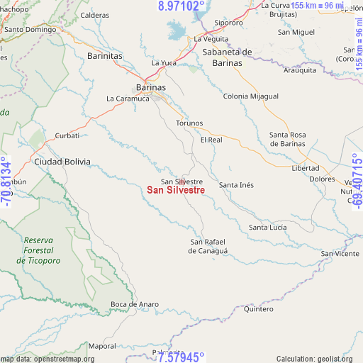
San Silvestre GPS coordinates[2]
8° 16' 33.06" North, 70° 6' 36.972" West
| Map corner | latitude | longitude |
|---|---|---|
| Upper-left | 8.97102°, | -70.8134° |
| Center: | 8.27585°, | -70.11027° |
| Lower-right: | 7.57945°, | -69.40715° |
| Map W x H: | 154.7×154.7 km | = 96.1×96.1mi |
| max Lat: | 11.94788° ⇑79.6% North |
| San Silvestre: | 8.27585° |
| min Lat: | ⇓20.4% South 1.92027° |
| min Long | San Silvestre | max Long |
| -72.55212° | -70.11027° | -60.99778° |
| W 33.6%⇐ | ⇒66.4% E |
Elevation
Elevation of San Silvestre is 128 m = 420 ft, and this is 252.6 m = 829 ft below average elevation for this country.
| Max E: |
2986 m = 9797 ft | 61.3% |
| Avg. | 380.6 m = 1249 ft | |
| San Silvestre | 128 m = 420 ft | |
Min E: |
-4 m = -13 ft | 38.7% |
See also: Venezuela elevation on elevation.city.
Geographical zone
San Silvestre is located in North Torrid zone (between Equator and Tropic of Cancer). Distance of Equator is 920.2 km =571.8 mi to South.| Distance of | km | miles | from San Silvestre |
|---|---|---|---|
| North Pole | 9086.9 | 5646.3 | to North |
| Arctic Circle | 6481 | 4027.1 | to North |
| Tropic Cancer | 1685.7 | 1047.4 | to North |
| Equator | 920.2 | 571.8 | to South |


Nearby cities:
15 places around San Silvestre: (largest is in red/bold)
• Alto Barinas
37.5 km =23.3 mi,  340°
340°
• Barinas
40 km =24.9 mi, 344°
• Caramuca
42.6 km =26.5 mi,  327°
327°
• El Corozo
42.3 km =26.3 mi,  319°
319°
• El Real
21.7 km =13.5 mi,  35°
35°
• La Luz
34.2 km =21.3 mi,  67°
67°
• La Mula
43.9 km =27.3 mi, 318°
• La Yuca
51.2 km =31.8 mi,  351°
351°
• Los Guasimitos
45.2 km =28.1 mi, 342°
• Obispos
36.8 km =22.9 mi,  0°
0°
• San Rafael de Canaguá
29.9 km =18.6 mi,  158°
158°
• Santa Inés
23.4 km =14.5 mi,  93°
93°
• Santa Lucía
41.4 km =25.7 mi,  117°
117°
• Santa Rosa
48.6 km =30.2 mi, 67°
• Torunos
25.2 km =15.7 mi,  7°
7°
Sources, notices
• [Note1] Compared only with cities in Venezuela existing in our database
• [Src1] Map data: © OpenStreetMap contributors (CC-BY-SA)
• [Src2] Other city data from geonames.org with taken over terms of usage.
• [Src3] Geographical zone / Annual Mean Temperature by Robert A. Rohde @ Wikipedia
