Santa Inés geodata
Santa Inés (Barinas) is a seat of a third-order administrative division; located in Venezuela in America/Caracas (GMT-4) time zone. In our database, there are 108 cities with bigger population. Compared to other cities in Venezuela, 80.2% of cities are located further ↑North; 63.1% of cities are located further →East and 63.6% of cities have higher elevation than Santa Inés. Note1
Administrative division(s):
- Level 1: Barinas
- Level 2: Municipio Barinas
- Level 3: Parroquia Santa Inés


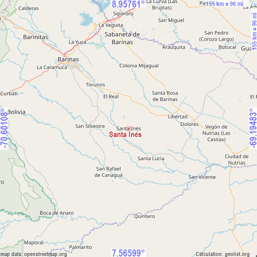
Santa Inés GPS coordinates[2]
8° 15' 44.676" North, 69° 53' 52.62" West
| Map corner | latitude | longitude |
|---|---|---|
| Upper-left | 8.95761°, | -70.60108° |
| Center: | 8.26241°, | -69.89795° |
| Lower-right: | 7.56599°, | -69.19483° |
| Map W x H: | 154.7×154.7 km | = 96.1×96.1mi |
| max Lat: | 11.94788° ⇑80.2% North |
| Santa Inés: | 8.26241° |
| min Lat: | ⇓19.8% South 1.92027° |
| min Long | Santa Inés | max Long |
| -72.55212° | -69.89795° | -60.99778° |
| W 36.9%⇐ | ⇒63.1% E |
Elevation
Elevation of Santa Inés is 115 m = 377 ft, and this is 265.6 m = 871 ft below average elevation for this country.
| Max E: |
2986 m = 9797 ft | 63.6% |
| Avg. | 380.6 m = 1249 ft | |
| Santa Inés | 115 m = 377 ft | |
Min E: |
-4 m = -13 ft | 36.4% |
See also: Venezuela elevation on elevation.city.
Geographical zone
Santa Inés is located in North Torrid zone (between Equator and Tropic of Cancer). Distance of Equator is 918.7 km =570.9 mi to South.| Distance of | km | miles | from Santa Inés |
|---|---|---|---|
| North Pole | 9088.4 | 5647.3 | to North |
| Arctic Circle | 6482.5 | 4028 | to North |
| Tropic Cancer | 1687.2 | 1048.4 | to North |
| Equator | 918.7 | 570.9 | to South |


Nearby cities:
15 places around Santa Inés: (largest is in red/bold)
• Alto Barinas
51.5 km =32 mi,  315°
315°
• Arauquita
56.2 km =34.9 mi,  28°
28°
• Barinas
52.6 km =32.7 mi, 319°
• Dolores
36.6 km =22.7 mi,  85°
85°
• El Real
22.1 km =13.7 mi,  330°
330°
• La Luz
16.8 km =10.4 mi, 29°
• Las Casitas del Vegon de Nutrias
52.9 km =32.9 mi, 93°
• Libertad
30.2 km =18.8 mi,  76°
76°
• Obispos
44.6 km =27.7 mi, 329°
• Sabaneta
54.6 km =33.9 mi,  355°
355°
• San Rafael de Canaguá
28.9 km =18 mi,  204°
204°
• San Silvestre
23.4 km =14.5 mi,  273°
273°
• Santa Lucía
22.3 km =13.9 mi,  143°
143°
• Santa Rosa
29.3 km =18.2 mi,  47°
47°
• Torunos
33.2 km =20.6 mi, 322°
Sources, notices
• [Note1] Compared only with cities in Venezuela existing in our database
• [Src1] Map data: © OpenStreetMap contributors (CC-BY-SA)
• [Src2] Other city data from geonames.org with taken over terms of usage.
• [Src3] Geographical zone / Annual Mean Temperature by Robert A. Rohde @ Wikipedia
